Post Route Maps of the American West

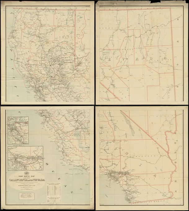
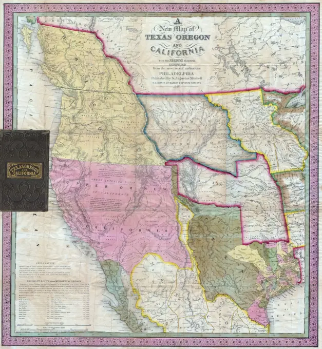
Maps detailing post routes in New Mexico and Arizona from the early 1900s, highlighting postal services and railroads, with clear geographic outlines.

Post route map of the territory of New Mexico showing post offices with the intermediate distances and mail routes in operation on the 1st of December, 1903 , Counties, New Mexico, Maps, Postal service, New Mexico, Maps, Railroads, New Mexico, Maps, New Mexico, Maps Norman B. Leventhal Map Center Collection
Map tenth division railway mail service. Copyright assigned to the International Textbook Company. "Entered at Stationers' Hall, London -- Printed in the United States." "ICSRL 129B-3242." Part of the I.C.S. reference library maps set.. Map showing railway mail service lines in North Central states Michigan, Wisconsin, Illinois (partial), Iowa (partial), Minnesota, North Dakota, South Dakota, Nebraska (partial), Wyoming (partial), Montana, Idaho (partial); boundaries for Yellowstone National Park marked out) in the early 20th century.. Tenth Division railway mail service Div. 10. Tenth Division railway mail service Div. 10, Northwestern United States  ,area  Midwest  ,areaJackson County, Wis.. Manuscript title in upper margin. Manuscript map in pen and ink. Part of a set of manuscript maps of Wisconsin counties. Shows townships and sections, rivers, railroads, stations and other features.... , Wisconsin  , Jackson  ,countyAegyptus antiqua.  Ancient Egypt. 1798 map by cartographer William Faden, engraved by Hatchett.  Faden was the royal geographer to King George III.  This map comes from his Atlas minimus universalis wMap of the province of Manitoba, shewing the surveys effected in 1871. Relief shown by hachures.... , Canada  , Province of Manitoba  ,provinceMap of Massachusetts showing population according to United States Census of 1900 and congressional districts , United States. Congress, Election districts, Maps, Election districts, Massachusetts, Maps, Massachusetts, Maps, Massachusetts, Population, 1900 Norman B. Leventhal Map Center CollectionDie Walachei , Wallachia, Maps Norman B. Leventhal Map Center CollectionMontana Territory , Montana, Maps Norman B. Leventhal Map Center CollectionArabian Gulf or Red Sea Thomas Bowen (died 1790). , 1788. Engraving, Sheet: 16 9/16 x 21 3/16 in. (42 x 53.8 cm).   European Art 1788USA Election of 1824 in which John Quincy Adams is elected President.  The election was decided in the House of RepresentativesRail road map of the southern states shewing the southern & southwestern railway connections with Philadelphia , Railroads, United States, Maps, United States, Maps Norman B. Leventhal Map Center CollectionMap of the Virginian Railway , Coal mines and mining, West Virginia, Maps, Coal mines and mining, Virginia, Maps, Forests and forestry, Virginia, Maps, Forests and forestry, West Virginia, Maps, Railroads, Virginia, Maps, Railroads, West Virginia, Maps, Virginia, Maps, West Virginia, Maps Norman B. Leventhal Map Center CollectionMap of the oil regions of western Pennsylvania and portions of eastern Ohio, New York, and West Virginia, compiled from the best authorities and recent surveys, 1864. Published by Horace J. Smith, Morgan Oil Company, Philadelphia. The map is hand-colored and measures 89 x 60 cmTracciamento della strada di ferro da Milano a Venezia. Shows a proposed railroad between Milan and Venice, with branches to major cities. A more sinuous railway connecting major cities was built. Relief shown by hachures.... , Italy  , Lombardy  ,regionA map titled 'Pestilence,' created in 1889 by the Department of the Interior, General Land Office. The map, measuring 70 x 89 cm on a sheet of 79 x 98 cm, depicts the state of Oregon, including its administrative and political divisions, along with Indian reservations. It is presented in color and mounted on cloth backing. The place of issuance is Washington, D.CTaylor County, Wis. , Taylor County Wis., Maps, Manuscript maps Norman B. Leventhal Map Center CollectionMap showing route of marches of the army of Genl. W.T. Sherman, from Atlanta, Ga. to Goldsboro, N.C : to accompany the report of operations from Savannah, Ga. to Goldsboro, N.C , Sherman's March to the Sea, Maps, Sherman's March through the Carolinas, Maps, South Atlantic States, History, Civil War, 1861-1865, Maps Norman B. Leventhal Map Center CollectionThis coloured map exhibits a general view of the economical geology of New York and part of the adjoining states, directed by the Honourable Stephen Van Rensselaer. It was issued in 1830 by the Rensselaer School in Troy, N.Y., and printed by Websters and Skinners in Albany, N.Y. The map measures 30 x 38 cmCarte du Perou, pour servir à l'histoire des Incas et à celle de l'etat present de cette province , Peru, Discovery and exploration, Maps, Early works to 1800, Amazon River, Discovery and exploration, Maps, Early works to 1800 Norman B. Leventhal Map Center CollectionPost route map of the states of California and Nevada showing post offices with the intermediate distances on mail routes in operation on the 1st of December, 1897 , Counties, California, Maps, Counties, Nevada, Maps, Postal service, California, Maps, Postal service, Nevada, Maps, Railroads, California, Maps, Railroads, Nevada, Maps, California, Maps, Nevada, Maps Norman B. Leventhal Map Center CollectionPost route map of the states of California and Nevada showing post offices with the intermediate distances on mail routes in operation on the 1st of December, 1897. Shows drainage, counties, railroads, etc. Insets: San Francisco Bay Area -- Los Angeles and vicinity. Includes lists of counties in California & Nevada.... , California NevadaMap of Manitoba , Manitoba, Maps Norman B. Leventhal Map Center CollectionAlberta, southern : map showing disposition of lands , Land use, Alberta, Maps, Real property, Alberta, Maps, Alberta, Maps Norman B. Leventhal Map Center CollectionBig Kopparberg's mountain team. From Carl Sahlin's mountain historical collection.Map of the region adjacent to the bay of San Francisco , San Francisco Bay Area Calif., Maps Norman B. Leventhal Map Center CollectionGeological map of the region in the vicinity of the Bow and Belly Rivers : embracing the southern portion of the District of Alberta and part of Assiniboia, Northwest Territory. Relief shown by hachures and spot heights. Includes cross section from Coal Creek to Medicine Hat.... , Canada  , Province of Alberta  ,province   , Bow  ,river  Belly River  ,riverStructure map of northeastern Oklahoma , Oklahoma, Maps, Geology, Structural, Oklahoma, Maps Norman B. Leventhal Map Center CollectionPost route map of the states of Oregon and Washington with adjacent states of Idaho, Nevada, California and British Columbia : showing post offices with the intermediate distances and mail routes in operation on the 1st of December, 1895 , Counties, Oregon, Maps, Counties, Washington State, Maps, Postal service, Oregon, Postal service, Washington State, Railroads, Oregon, Maps, Railroads, Washington State, Maps, Oregon, Maps, Washington State, Maps Norman B. Leventhal Map Center CollectionAlsace , Alsace France, Maps Norman B. Leventhal Map Center CollectionIndex chart of natural oyster bars, crab bottoms, clam bars and triangulation stations of Maryland surveyed by Maryland Shell Fish Commission in cooperation with United States Bureau of Fisheries and United States Coast and Geodetic Survey, 1906-1912 , Oysters, Habitat, Maryland, Maps, Oyster culture, Maryland, Maps, Crabs, Habitat, Maryland, Maps, Crab culture, Maryland, Maps, Clams, Habitat, Maryland, Maps, Triangulation, Maryland, Maps, Maryland, Maps Norman B. Leventhal Map Center CollectionOutline plan of Franklin County, 1876., 1876., Philadelphia, Franklin County (N.Y.). Real property, New York (State)British Columbia : Kamloops sheet, geologically coloured , Geology, British Columbia, Maps, Geology, British Columbia, Thompson-Nicola, Maps, Thompson-Nicola B.C., Maps, British Columbia, Maps Norman B. Leventhal Map Center CollectionNew map of the state of Minnesota showing the Saint Paul, Minneapolis and Manitoba Railway and its connections, 1879., 1879 ., Saint Paul, Minn. Publisher, Saint Paul, Minneapolis and Manitoba Railway., 1 map hand colored; 50 x 43 cm., A hand-colored map depicting the state of Minnesota, highlighting the Saint Paul, Minneapolis and Manitoba Railway and its connectionsAlgeria and Tunisia, port capacities and major transport routes. Map no. 970, August 22, 1942.... , Algeria Tunisia1846 Mitchell's Map of Texas Oregon and CaliforniaGallatin Township map from 1873, issued in Philadelphia by D. G. Beers & Co. The map details real property and business enterprises in Columbia County, New YorkMap of California and Nevada. Relief shown by shading and hachures. Shows drainage, counties, railroads, etc.... , California NevadaJansen Hermann (1869-1945), Groß-Berlin 1910. Straubeplan (01.07.1908): Competition documents: StraubePlan, measurement card with entry of the roads 1: 25000 specified according to the development plan. Colored pencil, ink colored, about pressure on cardboard, 94.7 x 114.7 cm (including scan edges) Jansen Hermann  (1869-1945): Wettbewerb Groß-Berlin 1910. StraubeplanPlan and sections, Oldham gold district, Halifax Co., N.S , Geology, Nova Scotia, Halifax County, Maps, Mines and mineral resources, Nova Scotia, Halifax County, Maps, Geology, Nova Scotia, Oldham, Maps, Mines and mineral resources, Nova Scotia, Oldham, Maps, Gold mines and mining, Nova Scotia, Maps, Halifax N.S. : County, Maps, Oldham N.S., Maps Norman B. Leventhal Map Center CollectionPlan and sections, Oldham gold district, Halifax Co., N.S. Includes 2 cross-section diagrams... Oldham gold district. Oldham gold district, Halifax County OldhamNorthern Alberta : map showing disposition of lands , Petroleum, Alberta, Maps, Natural gas, Alberta, Maps, Land use, Alberta, Maps, Real property, Alberta, Maps, Alberta, Maps Norman B. Leventhal Map Center CollectionMap of the Battle of Turcoing and Tournay - The Battle of Tourcoing (18 May 1794) saw a Republican French army directed by Joseph Souham defend against an attack by a Coalition army under Prince Josias of Saxe-Coburg-Saalfeld.Territory of New Mexico. Shows reservations, grants, claims and railroads. Relief shown by hachures. Prime meridians: Greenwich & Washington.... , New MexicoMap showing the boundary of the spread of over-frozen soil, opp. p. 436 Granitsa rasprostraneniia vechno merzloi pochvy O vechno merzloi pochve v Sibiri Imperatorskoe russkoe geograficheskoe obshchestvo. Cartographic. Maps. 1889. General Research Division. Geography, Russia , Maps, Permafrost , Russia , Siberia, Frozen ground19th century map of Indian Territory. Published in New Dollar Atlas of the United States and Dominion of Canada. (Rand McNally & Co's, Chicago, 1884).MAP OF THE WESTERN PART OF THE UNITED STATES OF AMERICA, 1899Holmdel Business Directory. ; Holmdel Township Cartographic. Atlases, Maps. 1873. Lionel Pincus and Princess Firyal Map Division. Monmouth Couty (N.J.) , Description and travel, Real property , New Jersey , Monmouth CountyPortland Village; Portland Business Directory; Villenova Business Directory; Brocton Village; Brocton Business Directory.; Villenova Township Cartographic. Atlases, Maps. 1867. Lionel Pincus and Princess Firyal Map Division. Chautauqua County (N.Y.), Real property , New York (State) , Chautauqua County, Business enterprises , New York (State) , Chautauqua CountyVermillion Village; Vermillion Business Directory; Palermo P.O. or Jennings Corners Business Directory; Palermo Township Cartographic. Atlases, Maps. 1867. Lionel Pincus and Princess Firyal Map Division. Oswego County (N.Y.), Real property , New York (State) , Oswego County, Business enterprises , New York (State) , Oswego CountyIndian Territory. Detached from a United States House of Representatives document in the United States congressional serial set (Serial Set 4459 H.doc.5/4), following page 164: Annual reports of the Department of the Interior for the fiscal year ended June 30, 1902. Indian affairs, part II. Washington : Government Printing Office, 1903. Base map dated 1898. At head of title: Department of the Interior. United States Geological Survey. Charles D. Walcott, director. In top margin: "Ninth annual report, Commission to the Five Civilized Tribes. Exhibit I." "Interior 56 2." Sshould read: 57 2... Map of Indian Territory (later to become the eastern part of the state of Oklahoma) showing the boundaries of the Cherokee, Chickasaw, Choctaw, Creek, and Seminole nations. Also shows railroads, Public Land Survey System townships, cities and towns, and water features... , OklahomaMap of Cleveland & Toledo Rail Road, with its connections. Includes distances table.... , Northeastern United States  ,areaDewittville Village; Hartfield Village; Arkwright Township; Hartfield Business Directory; Dewittville Business Directory Cartographic. Atlases, Maps. 1867. Lionel Pincus and Princess Firyal Map Division. Chautauqua County (N.Y.), Real property , New York (State) , Chautauqua County, Business enterprises , New York (State) , Chautauqua CountyThe official railway map of Ohio, published in 1884 by R. Sutton. The map is hand-colored and measures 52 x 55 cm. It provides an overview of the railroad system in Ohio and was issued in Wapakoneta, OhioA new map of Nebraska, Kansas, New Mexico, and Indian Territories , West U.S., Maps Norman B. Leventhal Map Center CollectionA new map of Nebraska, Kansas, New Mexico, and Indian Territories. Relief shown by hachures. Prime meridians: Washington and Greenwich. "Entered according to Act to Congress, in the year 1850, by Thomas Cowperthwait & Co. ..."... , Western United States  ,areaIndian Territory. Bacon's new large-print map of Alaska & the Klondike : compiled from the most recent government surveys and showing routes to the gold fields. Relief shown by shading. Inset: Location map showing other goldfields. Includes notes... Bacon's new large-print map of Alaska and the Klondike. Bacon's new large-print map of Alaska and the Klondike, Alaska Canada  , Yukon Territory  ,territory   , Klondike  ,riverTown of Batavia Township, 1876., 1876., Philadelphia, Genesee County (N.Y.). Real property, New York (State)Iraq water supply and land use , Water-supply, Iraq, Maps, Land use, Iraq, Maps, Precipitation Meteorology, Iraq, Maps, Iraq, Maps Norman B. Leventhal Map Center CollectionTopographical map of the seat of the war. Relief shown by shading. "By the American Photo-Lithographic Co. (Osborne's Process)." Insets: Paris -- Strasbourg -- Metz. Wrapper in 6 panels, with text in German and English... Schedler's topographical map of the seat of war : with plans of the fortresses of Paris, Metz and Strasbourg. Schedler's topographical map of the seat of war : with plans of the fortresses of Paris, Metz and Strasbourg, FranceMississippi River Flood of 1927 Showing Flooded Areas and Field of OperationsTtahuantin-Suyu or the empire of the Yncas (except Quito and Chile) ... conquerers , Incas, Maps, Incas, History, Maps, Peru, Historical geography, Maps, 1523-1608 Norman B. Leventhal Map Center CollectionMexico Township Cartographic. Atlases, Maps. 1867. Lionel Pincus and Princess Firyal Map Division. Oswego County (N.Y.), Real property , New York (State) , Oswego County, Business enterprises , New York (State) , Oswego CountyRoutes of Grand Trunk Pacific Steamships : Pacific coast service , Railroads, British Columbia, Maps, Railroads, Yukon, Maps, Steamboats, British Columbia, Maps, Steamboats, Yukon, Maps, Steamboats, Alaska, Maps, British Columbia, Maps, Yukon, Maps, Alaska, Southeast, Maps, Canadian Cordillera, Maps Norman B. Leventhal Map Center CollectionAlberta, southern : map showing disposition of lands. Relief shown by spot heights.... , Canada  , Province of Alberta  ,provinceLindleytown Village; Lindley Township; Lindley Business Notices Cartographic. Atlases, Maps. 1873. Lionel Pincus and Princess Firyal Map Division. Steuben County (N.Y.), Real property , New York (State) , Steuben County, Business enterprises , New York (State) , Steuben CountyGeographical, topographical, state highway and railroad map of California , Railroads, California, Maps, Steamboat lines, California, Maps, Roads, California, Maps, California, Maps Norman B. Leventhal Map Center CollectionOrnament with a chessboard pattern and flowers. Leaf 7 Verso from a sketchbook with 11 sheets.Topographical map of Virginia between Washington and Manassas Junction , United States Capitol Washington, D.C., Pictorial works, Washington D.C., History, Civil War, 1861-1865, Maps, Washington Metropolitan Area, History, Maps, Manassas Region Va., History, Maps, Virginia, History, Civil War, 1861-1865, Maps Norman B. Leventhal Map Center CollectionMap of the Indian Territory : showing the progress and status of townsite surveys, under the direction of the United States Indian Inspector for the Indian Territory, June 20, 1902 , Indian Territory, Maps, Oklahoma, Maps, Cities and towns, Indian Territory, Surveys, Maps, Indian reservations, Oklahoma, Maps Norman B. Leventhal Map Center CollectionMap of the central portion of British Columbia , British Columbia, Maps Norman B. Leventhal Map Center CollectionIndian Territory showing townsites approved to June 30-1902 , Indian Territory, Maps, Oklahoma, Maps, Cities and towns, Indian Territory, Maps, City planning, Indian Territory, Maps, Indian reservations, Oklahoma, Maps Norman B. Leventhal Map Center CollectionOrnament with a chessboard pattern and flowers, c. 1925  Page 7 Verso from a sketchbook with 11 sheets.  pencil  ornaments ~ artNew map of the American overland route showing its connections, and land grants of 30,000,000 acres , Railroads, United States, Maps, Railroads, West U.S., Maps, Railroad land grants, West U.S., Maps, United States, Maps, Union Pacific Railroad Company Norman B. Leventhal Map Center CollectionMaps and Charts - All States. Photographs Relating to National Forests, Resource Management Practices, Personnel, and Cultural and Economic HistoryGilman's Hot Springs, relief , Maps, Tichnor Brothers Collection, postcards of the United StatesCobb's latest map of the Rosebud Reservation, South Dakota, to be opened for settlement Aug. 8, 1904 , Rosebud Indian Reservation S.D., Maps, Gregory County S.D., Maps, Land tenure, South Dakota, Gregory County, Indian land transfers, South Dakota, Dakota Indians, Land tenure Norman B. Leventhal Map Center CollectionCobb's latest map of the Rosebud Reservation, South Dakota, to be opened for settlement Aug. 8, 1904 , Rosebud Indian Reservation S.D., Maps, Gregory County S.D., Maps, Land tenure, South Dakota, Gregory County, Indian land transfers, South Dakota, Dakota Indians, Land tenure Norman B. Leventhal Map Center CollectionEdwards Village; Edwards Business Directory. Edwards Township, 1865, Beers, S. N., 1865, Philadelphia, Saint Lawrence County (N.Y.), Real property, New York (State)Map of part of Colorado Territory showing survey west of Denver City, 1864, Union Pacific Railroad Company., 1864., New York. Publisher, Union Pacific Railroad Company. Railroads, Colorado., 1 map color; 29 x 91 cm, on sheet 34 x 95 cmStockholm Township Cartographic. Atlases, Maps. 1865. Lionel Pincus and Princess Firyal Map Division. Saint Lawrence County (N.Y.), Real property , New York (State) , Saint Lawrence County