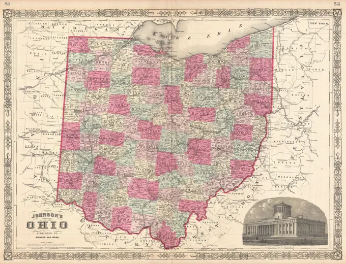
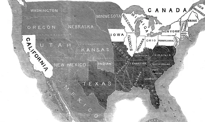
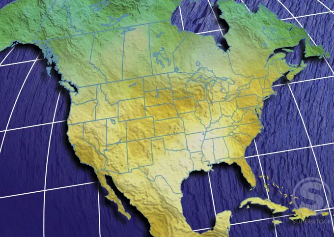
My Boards
View Pictures
  • My Boards

Railroad and Geographic Maps

Detailed maps of the United States showcasing railroads and geographical features, essential for navigation and land use in different eras.

Vintage Railroad Map of the United States of America, ,  Rand McNally, 1888
Vintage Railroad Map of the United States of America, , Rand McNally, 1888
166 assets in this story
4443-75461231
Map of the United States of America, 1873., 1873., New York, N.Y., Hunterdon County (N.J.). Maps
6145-54348031
Maps and Charts - All States. Photographs Relating to National Forests, Resource Management Practices, Personnel, and Cultural and Economic History
6145-54276540
177 Years of French-US Friendship Exhibit (Opening Visitors and Documents Exhibited). Photographs of Marshall Plan Programs, Exhibits, and Personnel
6145-55957464
Gray's Geological Map of the United States Cartographic. Atlases, Maps. 1876. Lionel Pincus and Princess Firyal Map Division. Dutchess County (N.Y.)
6145-54372205
Tree Identification - Oak: Swamp White. Photographs Relating to National Forests, Resource Management Practices, Personnel, and Cultural and Economic History
6145-29095259
1864 Johnson Map of Ohio
6145-54269502
Victory map 1919. Outline map of the contiguous United States showing the status of woman suffrage in each state. Includes notes.. The campaign to extend the vote to women had been fought for over 70 years and success finally came with the adoption of the 19th amendment in 1920. This battle had been waged state by state and as this map indicates, it was in the western portion of the country where women first gained the right to vote although there was ardent agitation from their sisters in the east. It was in the individual statehouses, controlled by male legislators, that their fate was finally determined. As the map indicates, women accepted partial suffrage before receiving the full vote with the Constitutional Amendment... , United States
6145-51929671
Civil airways of the United States as designated in Civil Air Regulations - chapter 60. Also shows locations of radio facilities. "Nov. 22, 1937."... , United States
6145-51396892
National highways map of the United States showing principal transcontinental highways and connecting system of one hundred thousand miles of national highways proposed by the National Highways Association , Roads, United States, Maps Norman B. Leventhal Map Center Collection
4220-20401715
Pre Civil War map of the USA, showing the distribution of States where slavery was widespread: free (marked in white) and slave states (black), and unsettled territory (grey).  1856
6176-66916234
Schönberg's map of Texas, circa 1866
6145-55915858
Official map of American and Canadian airways and aerial mail routes. Includes text and lists of cities, towns, and villages in airways.... , North America  ,area
6145-54373953
Tree Identification - Ash. Photographs Relating to National Forests, Resource Management Practices, Personnel, and Cultural and Economic History
6145-54348130
Maps and Charts - All States. Photographs Relating to National Forests, Resource Management Practices, Personnel, and Cultural and Economic History
6145-54348196
Maps and Charts - All States. Photographs Relating to National Forests, Resource Management Practices, Personnel, and Cultural and Economic History
6145-55963705
Rural cultural regions in the United States
6145-55915621
New map of the state of Texas. Relief shown by hachures. Prime meridians: Greenwich and Washington. Insets: Plan of the northern part of Texas -- Plan of Galveston Bay -- Plan of Sabine Lake. "Entered according to Act of Congress in the year 1856 by J.H. Colton & Co. ..."... , Texas  , Galveston Bay Sabine Pass
6145-54373803
Tree Identification - Bladdernut. Photographs Relating to National Forests, Resource Management Practices, Personnel, and Cultural and Economic History
6145-54348065
Maps and Charts - All States. Photographs Relating to National Forests, Resource Management Practices, Personnel, and Cultural and Economic History
6145-54373780
Tree Identification - Birch. Photographs Relating to National Forests, Resource Management Practices, Personnel, and Cultural and Economic History
6145-50543374
Free public libraries of Massachusetts , Public libraries, Massachusetts, Statistics, Public libraries, Massachusetts, Maps Norman B. Leventhal Map Center Collection
6145-29210686
United States from Court Game of Geography 1838-55 William and Henry Rock. United States from Court Game of Geography. 1838-55. Engraving and hand coloring (watercolor). William and Henry Rock
6145-50565653
Rand McNally standard map of Alaska , Alaska, Maps, Railroads, Alaska, Maps Norman B. Leventhal Map Center Collection
6145-54348140
Maps and Charts - All States. Photographs Relating to National Forests, Resource Management Practices, Personnel, and Cultural and Economic History
6145-58942559
Description: Panama Pacific Line. New York - California Location: United States of America Date: 1935
6145-51398181
Pictorial map of the United States, 1849 , United States, Maps Norman B. Leventhal Map Center Collection
6176-66919170
This porcineograph - Map of the United States in shape of a pig, surrounded by pigs representing the different states, with notations of state foods, circa 1876
6145-54371142
Tree Identification - Sequoia. Photographs Relating to National Forests, Resource Management Practices, Personnel, and Cultural and Economic History
6145-50571532
P.W.A. in action , United States, Maps, United States, History, 1933-1945, Maps, United States. Public Works Administration Norman B. Leventhal Map Center Collection
6145-50571460
Illustrierte karte der Vereinigten Staaten von Amerika : mit darstellung der regionalen bodenschätze, produkte und landschaftlichen besonderheiten , Transportation, United States, Maps, United States, Maps, United States, Economic conditions, Maps Norman B. Leventhal Map Center Collection
1152-104
Close-up of a map of North America
6145-51393584
Illustrierte karte der Vereinigten Staaten von Amerika : mit darstellung der regionalen bodenschätze, produkte und landschaftlichen besonderheiten , Transportation, United States, Maps, United States, Maps, United States, Economic conditions, Maps Norman B. Leventhal Map Center Collection
6145-55913978
Illustrierte karte der Vereinigten Staaten von Amerika : mit darstellung der regionalen bodenschatze, produkte und landschaftlichen besonderheiten. Pictorial map showing mineral and agricultural resources, places of interest, etc. Relief shown by hachures and spot heights. Includes text, 2 hemisphere maps showing the location of the United States and 3 insets. Insets: Haupt-eisenbahnlinien -- Haupt-flugrouten und gebiete -- Haupt-uberlandsstrassen. "Diese karte ist außerhalb der Vereinigten Staaten bei allen dienststellen des United States Information Service kostenlos erhaltlich."... , United States
6145-55167728
A Texan's map of the United States of Texas. Cartoon pictorial map showing Texas as occupying about half of the area of the United States, with comic place names. "Scale of miles: 1 Texas inch = 1,000 miles."... , United States
4048-22159608
UNITED STATES OF GUGGENHEIMERICA Cartoon by Willard H. Walker satirizes Interior Secretary Ballinger's lease of coal land in Alaska to the mining industrialist family, the Guggenheims. On left are the Guggenheim family. On right are J.P. Morgan, Rockefeller, and Andrew Carnegie, lining up for their share (BSLOC_2017_2_127)
6145-54373079
Tree Identification - Hemlock: Eastern. Photographs Relating to National Forests, Resource Management Practices, Personnel, and Cultural and Economic History
1899-18978958
1936 Resettlement Administration Projects Map CA 1935-1936 (part of the Farmers Home Administration).
6145-54372232
Tree Identification - Oak: Scarlet. Photographs Relating to National Forests, Resource Management Practices, Personnel, and Cultural and Economic History
6145-50568233
Great Northern Railway and proprietary lines , Great Northern Railway Company U.S., Railroads, West U.S., Maps, West U.S., Maps Norman B. Leventhal Map Center Collection
6145-51395776
National highways map of the United States showing one hundred fifty thousand miles of national highways proposed by the National Highways Association , Roads, United States, Maps Norman B. Leventhal Map Center Collection
6145-55915412
National highways map of the United States showing one hundred fifty thousand miles of national highways proposed by the National Highways Association. Text and ill. in margins.... , United States
6145-55915274
Massachusetts outdoor recreation plan 1966 : public outdoor recreation areas. Indicates state forests, parks and beaches; metropolitan district commission; public reservations; and federal lands. Also shows regions.. Accompanies a report on present and future demand, supply, and needs for outdoor recreation resources and facilities in Massachusetts together with a program of implementation to meet these needs... , Massachusetts
6145-54348077
Maps and Charts - All States. Photographs Relating to National Forests, Resource Management Practices, Personnel, and Cultural and Economic History
6145-51393380
38,000,000 escaped -- 10,000,000 died , World War, 1939-1945, Maps, World War, 1939-1945, Civilian relief, Soviet Union, Maps, Russians, Nazi persecution, Maps, United States, Maps, Soviet Union, Maps, Russian War Relief, Inc. Norman B. Leventhal Map Center Collection
6145-55917903
38,000,000 escaped -- 10,000,000 died. Shows "the western half of the Soviet Union ... placed (in reverse) upon the map of the United States." Relief shown pictorially. "E. Means"--Below legend. "Russian War Relief, Inc., 11 E. 35th St., New York City, presents this map to help Americans to visualize the almost inconceivable extent of the need for American aid to the people of the Soviet Union. From the vast invaded area of the USSR, here shown superimposed on a map of the United States ..."... , United States
6176-66917269
Location of Indian Tribes, 1492
6145-54348082
Maps and Charts - All States. Photographs Relating to National Forests, Resource Management Practices, Personnel, and Cultural and Economic History
6145-54370877
Tree Identification - Tupelo: Black. Photographs Relating to National Forests, Resource Management Practices, Personnel, and Cultural and Economic History
6145-52054016
Maps and Charts - All States. Photographs Relating to National Forests, Resource Management Practices, Personnel, and Cultural and Economic History
1899-11210
United States and Texas State Map. ca. 1948, Texas, USA, THE UNITED STATES AS SEEN THROUGH THE EYES OF TEXAS
6145-48433839
A series of statistical charts illustrating the condition of the descendants of former African slaves now in residence in the United States of America Distribution of Negroes in the United States. African American Photographs Assembled for 1900 Paris Exposition.
6145-54348062
Maps and Charts - All States. Photographs Relating to National Forests, Resource Management Practices, Personnel, and Cultural and Economic History
6145-51386890
Rambles through our country : an instructive geographical game for the young , Board games, United States, Maps, Educational games, Maps, United States, Maps Norman B. Leventhal Map Center Collection
1838-2036
USA Map with Red Push-Pins
6145-48719865
Nuclear America , United States, Maps, Nuclear facilities, United States, Maps, Radioactive fallout, United States, Maps Norman B. Leventhal Map Center Collection
6145-50557936
Nuclear America , United States, Maps, Nuclear facilities, United States, Maps, Radioactive fallout, United States, Maps Norman B. Leventhal Map Center Collection
6145-54348028
Maps and Charts - All States. Photographs Relating to National Forests, Resource Management Practices, Personnel, and Cultural and Economic History
6145-43861051
Electoral votes for President in 1916 and for Congress in 1918 : make your guess for 1920 , Elections, United States, Maps, United States, Maps Norman B. Leventhal Map Center Collection
6145-55913440
America's other 60 families : the real rulers of America. Outline map of the United States overshadowed by a square inset of the Union Square area and a square area listing 60 organizations. Lists organization, address in Union Square, prominent members, and some also include organization size or activity. "Radical Union Square is the fountainhead of the propaganda of discontent." "All data used in compiling this chart are from official documents and/or accredited publications of "America's other 60 families" A. Cloyd Gill (Author, the forthcoming book, America's other 60 families).".. Wake up America : repel the grave diggers of capitalism! Shall Union Square overshadow the United States. Wake up America : repel the grave diggers of capitalism! Shall Union Square overshadow the United States, New York  , New York Union Square
6145-50571547
Armour food source map , United States, Maps, Food supply, United States, Maps, Food industry and trade, United States, Maps, Agriculture, United States, Maps, Farm produce, United States, Maps Norman B. Leventhal Map Center Collection
6145-43861834
Portugal is not a small country , Portugal, Maps, Portugal, Colonies, Maps, United States, Maps, Postcards Norman B. Leventhal Map Center Collection
6145-43932849
Greetings from Nebraska , Maps, Tichnor Brothers Collection, postcards of the United States
6145-51395768
A nation of immigrants , United States, Maps, Immigrants, United States, Maps, Industries, United States, Maps Norman B. Leventhal Map Center Collection
6145-55915408
A nation of immigrants. Pictorial map showing prominent immigrant groups, industries, and symbols of states. Relief shown by hachures. Includes text. Border lists nationalities incorporated in map. "This map is designed as a companion piece to John F. Kennedy's pamphlet, 'A nation of immigrants.'"... , United States
6145-48558388
Chew Lorillard's 'Splendid' plug tobacco, in fair weather and foul. , Flags, Smokeless tobacco, 19th Century American Trade Cards
6145-54416284
A viewgraph showing former Naval Station, Truman Annex, Key West, Florida. The viewgraph shows the present and projected use of the land. The Navy plans to reopen the former Naval Station, Trumen Annex, Key West, Florida, as a forward operating base in support of naval operations and exercises in the Florida Straits. This area is to the left, marked retained. Country: Unknown
PREVIOUS
of 2
NEXT
2401 S. Ervay, Suite 206
Dallas, Texas 75215
United States
Get Started
Free ResearchMy BoardsMy Cart
For Creators
How To License Your ContentContributor PortalFrame of Mind
Resources
API accessPricing
Contact
+1 866 236 0087help@viewpictures.co.uk Contact form
©2026 View Pictures. All Rights Reserved. -A
This site is protected by reCAPTCHA and Google Privacy Policy and Terms of Service apply.