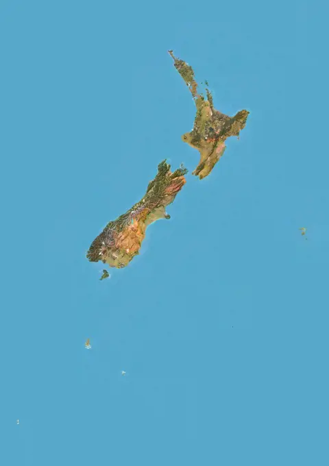
My Boards
View Pictures
  • My Boards
← Science

Satellite Maps of Regions

Satellite imagery showing geographical relief and features of various regions, including color-coded maps of Ecuador, Venezuela, Nicaragua, Guatemala, and Brunei.

Color satellite image of Honduras and neighbouring countries.
398 assets in this story
1899-21290071
North Africa at night in 2012. This satellite image with country borders shows urban and industrial lights.
1899-80066
Satellite view of Mexico (with border and mask). This image was compiled from data acquired by LANDSAT 5 & 7 satellites.
1899-53517960
Color satellite image of Italy and neighbouring countries, with borders.
1899-21289880
Satellite view of Luzon, Philippines. It is the largest and most populous island in the Philippines. This image was compiled from data acquired by Landsat satellites.
1899-66809
Relief map of Netherlands (with border and mask). This image was compiled from data acquired by landsat 5 & 7 satellites combined with elevation data.
1899-53517704
Color satellite image of the Bahamas in the West Indies.
1899-80864
Relief map of Italy showing the region of Liguria. This image was compiled from data acquired by LANDSAT 5 & 7 satellites combined with elevation data.
1899-80058
Satellite view of Mauritania (with border and mask). This image was compiled from data acquired by LANDSAT 5 & 7 satellites.
1899-81930
Satellite view of Upper Normandy, France. This image was compiled from data acquired by LANDSAT 5 & 7 satellites.
1899-79775
Relief map of The Dominican Republic (with border and mask). This image was compiled from data acquired by landsat 5 & 7 satellites combined with elevation data.
1899-21289759
Satellite view of North and South Korea (with country boundaries). This image was compiled from data acquired by Landsat satellites.
1899-35144
South Korea, Asia, True Colour Satellite Image With Border And Mask. Satellite view of South Korea (with border and mask). This image was compiled from data acquired by LANDSAT 5 & 7 satellites.
1899-66807
Relief map of Namibia (with border and mask). This image was compiled from data acquired by landsat 5 & 7 satellites combined with elevation data.
1899-35299
Marshall Islands And Kiribati, Micronesia, Oceania, True Colour Satellite Image. Satellite view of the Marshall Islands and Kiribati, located in the Pacific ocean. This image was compiled from data acquired by LANDSAT 5 & 7 satellites.
1899-80435
Relief map of Argentina showing the province of La Rioja. This image was compiled from data acquired by LANDSAT 5 & 7 satellites combined with elevation data.
1899-80420
Relief map of Argentina showing the province of Corrientes. This image was compiled from data acquired by LANDSAT 5 & 7 satellites combined with elevation data.
1899-82102
Satellite view of the region of Kyushu, Japan. This image was compiled from data acquired by LANDSAT 5 & 7 satellites.
1899-80855
Relief map of Italy showing the region of Emilia Romagna. This image was compiled from data acquired by LANDSAT 5 & 7 satellites combined with elevation data.
1746-19663163
Satellite image of Italy and the Balkans
1899-34881
Great Barrier Reef, Australia, True Colour Satellite Image. Satellite image of the Great Barrier Reef, the world's largest coral reef, located in the Coral Sea off the cost of Queensland in North-East Australia. Image taken on 18 July 1991 using LANDSAT data. Print size 42 x 8.4 cm.
1899-80893
Satellite view of Italy with boundaries of regions. This image was compiled from data acquired by LANDSAT 5 & 7 satellites.
1746-28998793
Satellite image showing the Sinai and Negev regios and the shrinking of the Dead Sea in Israel. 2012
1899-80062
Relief map of Mexico (with border and mask). This image was compiled from data acquired by landsat 5 & 7 satellites combined with elevation data.
1899-53517959
Color satellite image of Italy, with borders and mask.
1899-35099
Norway, Europe, True Colour Satellite Image With Border And Mask. Satellite view of Norway (with border and mask). This image was compiled from data acquired by LANDSAT 5 & 7 satellites.
1899-81671
Relief map of the State of Queensland, Australia. This image was compiled from data acquired by LANDSAT 5 & 7 satellites combined with elevation data.
1899-80879
Relief map of Italy showing the region of Trentino-Alto Adige. This image was compiled from data acquired by LANDSAT 5 & 7 satellites combined with elevation data.
1899-80867
Relief map of Italy showing the region of Lombardy. This image was compiled from data acquired by LANDSAT 5 & 7 satellites combined with elevation data.
1899-21289737
Satellite view of Israel (with country boundaries). This image was compiled from data acquired by Landsat 8 satellite in 2014.
1899-80459
Relief map of Argentina showing the province of Santa Cruz. This image was compiled from data acquired by LANDSAT 5 & 7 satellites combined with elevation data.
1899-80873
Relief map of Italy showing the region of Piedmont. This image was compiled from data acquired by LANDSAT 5 & 7 satellites combined with elevation data.
1899-35049
Mexico, North America, True Colour Satellite Image With Border. Satellite view of Mexico (with border). This image was compiled from data acquired by LANDSAT 5 & 7 satellites.
1746-28998797
Satellite image showing the Sinai and Negev regions and the shrinking of the Dead Sea in Israel. 2017
1899-21289670
Satellite view of Europe (with country boundaries). This image was compiled from data acquired by Landsat 7 & 8 satellites.
1899-80438
Relief map of Argentina showing the province of Mendoza. This image was compiled from data acquired by LANDSAT 5 & 7 satellites combined with elevation data.
1899-34634
Israel, True Colour Satellite Image. Israel, true colour satellite image. North is at top. The large central body of water is the Dead Sea, with Jerusalem visible to the left of its northern tip. The border with Jordan, the 1967 ceasefire line, runs along the central line joining the inland bodies of water. To the West is the Gaza strip, bordering Egypt, and to the North is the border with Lebanon. LANDSAT composite satellite image. This image was compiled from data acquired by LANDSAT 5 & 7 sat
1899-80251
Satellite view of Solomon Islands with Bump Effect (with border). This image was compiled from data acquired by LANDSAT 5 & 7 satellites.
1899-79951
Satellite view of Jamaica with Bump Effect. This image was compiled from data acquired by LANDSAT 5 & 7 satellites.
1899-81877
Satellite view of Brittany, France. This image was compiled from data acquired by LANDSAT 5 & 7 satellites.
1525-22923951
Mexican gulf map. Elements of this image furnished by NASA. 3d rendering. Mexican gulf map
1899-80468
Relief map of Argentina showing the province of Tierra del Fuego. This image was compiled from data acquired by LANDSAT 5 & 7 satellites combined with elevation data.
1899-80876
Relief map of Italy showing the region of Marche. This image was compiled from data acquired by LANDSAT 5 & 7 satellites combined with elevation data.
1899-79940
Relief map of Italy (with border and mask). This image was compiled from data acquired by landsat 5 & 7 satellites combined with elevation data.
6145-44599815
Data from NASA's Terra spacecraft were combined to create this cloud-free natural-color mosaic of Scandinavia and the Baltic region.
1899-21289965
Satellite view of Sweden (with country boundaries). This image was compiled from data acquired by Landsat satellites.
1899-35912
Japan, True Colour Satellite Image With Mask. Japan, true colour satellite image with mask. Japan is an archipelago of islands in the northern Pacific Ocean. Japan's capital city, Tokyo (grey, right centre), is situated on Japan's main island, Honshu. Japan's second largest island, Hokkaido, lies to the north of Honshu. This image was compiled from data acquired by LANDSAT 5 & 7 satellites.
1899-21289616
Satellite view of Christmas Island, Kiribati. This image was compiled from data acquired by Landsat 8 satellite in 2014.
1899-80444
Relief map of Argentina showing the province of Neuquen. This image was compiled from data acquired by LANDSAT 5 & 7 satellites combined with elevation data.
1899-53517949
Color satellite image of Ireland.
1899-35776
Lake Nicaragua, Nicaragua, True Colour Satellite Image. True colour satellite image of Lake Nicaragua, a vast freshwater lake in South Nicaragua. Composite image from January 2000 using LANDSAT 7 data.
1899-35321
Norway, Europe, True Colour Satellite Image With Mask. Satellite view of Norway (with mask). This image was compiled from data acquired by LANDSAT 5 & 7 satellites.
1899-80837
Relief map of Italy showing the region of Abruzzo. This image was compiled from data acquired by LANDSAT 5 & 7 satellites combined with elevation data.
1899-80219
Relief map of Saudi Arabia (with border). This image was compiled from data acquired by LANDSAT 5 & 7 satellites combined with elevation data.
6145-44880256
Extremely heavy rains fell at the end of February 2012 in the northern Algerian province of El Tarf, near the Tunisian border. The rainfall total was the greatest recorded in the last 30 years. This image is from NASA's Terra spacecraft.
1899-80941
Relief map of Mexico showing the State of Hidalgo. This image was compiled from data acquired by LANDSAT 5 & 7 satellites combined with elevation data.
1899-80973
Relief map of Mexico showing the State of Yucatan. This image was compiled from data acquired by LANDSAT 5 & 7 satellites combined with elevation data.
1899-79744
Relief map of Cuba (with border). This image was compiled from data acquired by LANDSAT 5 & 7 satellites combined with elevation data.
1899-21289625
Satellite view of Cuba and Jamaica. This image was compiled from data acquired by Landsat satellites.
1899-21289861
Satellite view of Norway (with country boundaries). This image was compiled from data acquired by Landsat satellites.
1899-80951
Relief map of Mexico showing the State of Nuevo Leon. This image was compiled from data acquired by LANDSAT 5 & 7 satellites combined with elevation data.
1899-21289973
Satellite view of Tenerife, Canary Islands, Spain. It is the largest and most populous island of the seven Canary Islands. Volcano Mount Teide at center is the highest point of Spain, at 3718 m. This image was compiled from data acquired by Landsat 8 satellite in 2014.
1899-53518056
Color satellite image of Mexico, with borders and mask.
1899-21289697
Satellite view of Guadeloupe, Dominica and Martinique. This image was compiled from data acquired by Landsat satellites.
1525-22914871
Saudi Arabia and Somalia map. Elements of this image furnished by NASA. 3d rendering. Saudi Arabia and Somalia map
6145-44969024
ISS036-E-025984 (29 July 2013) --- One of the Expedition 36 crew members aboard the Earth-orbiting International Space Station took this night picture of Sicily in the Mediterranean Sea on July 29, 2013. The Stretto de Messina is just out of frame at bottom left.
1525-24704442
World Map of CENTRAL AMERICA and CARIBBEAN BASIN REGION: Mexico, Cuba, Guatemala, Yucatan, Caribbean Islands, Antilles, Bahamas, Panama Canal. Geographic chart with coastline, sea, gulf, islands.
1899-21290078
West and Southern Africa at night in 2012. This satellite image with country borders shows urban and industrial lights.
1899-80217
Satellite view of Sao Tome and Principe. This image was compiled from data acquired by LANDSAT 5 & 7 satellites.
1899-80955
Relief map of Mexico showing the State of Puebla. This image was compiled from data acquired by LANDSAT 5 & 7 satellites combined with elevation data.
1899-80486
Satellite view of Australia showing the State of Tasmania. This image was compiled from data acquired by LANDSAT 5 & 7 satellites.
1899-80256
Relief map of South Africa (with border and mask). This image was compiled from data acquired by landsat 5 & 7 satellites combined with elevation data.
6145-44597714
This image of South America was generated with data from NASA's Shuttle Radar Topography Mission (SRTM).
1899-53518178
Color satellite image of Saudi Arabia, with borders and mask.
1899-80918
Relief map of Japan with boundaries of regions. This image was compiled from data acquired by LANDSAT 5 & 7 satellites combined with elevation data.
1899-80935
Relief map of Mexico showing the State of Durango. This image was compiled from data acquired by LANDSAT 5 & 7 satellites combined with elevation data.
6145-45000264
This image acquired by NASA's Terra spacecraft is of the Kingdom of Bahrain, a small island country near the western shore of the Persian Gulf.
1899-82218
Relief map of the State of California, United States. This image was compiled from data acquired by LANDSAT 5 & 7 satellites combined with elevation data.
1899-53517695
Color satellite image of Australia.
1899-66722
Relief map of Benin (with border and mask). This image was compiled from data acquired by landsat 5 & 7 satellites combined with elevation data.
1899-80112
Satellite view of New Zealand with Bump Effect. This image was compiled from data acquired by LANDSAT 5 & 7 satellites.
6188-64570268
Karte der Salomonen mit Anzeiger für Vulkan - Map of the Solomon Islands with volcano locator Karte der Salomonen mit Anzeiger für Vulkan - Map of the Solomon Islands with volcano locator Copyright: xZoonar.com/lantapixx 14314438
1848-64398703
Map of South Georgia and the South Sandwich Islands, old green computer terminal screen, on dark background
1899-79924
Relief map of Iraq (with border and mask). This image was compiled from data acquired by landsat 5 & 7 satellites combined with elevation data.
1746-19665002
Phytoplankton in the Gulf of California
1899-21290144
Turkey at night in 2012. This satellite image with country borders shows urban and industrial lights.
1899-21289659
Satellite view of England and Wales, UK (with country boundaries). This image was compiled from data acquired by Landsat satellites.
6145-44583892
Digital elevation models (DEMs), such as those produced by NASA's Shuttle Radar Topography Mission (SRTM), allow user-controlled visualization of the Earth's landforms that is not possible using satellite imagery alone.
5507-37658518
Crimea Ukraine map aerial view
6145-44772473
The islands and coral atolls of French Polynesia, located in the southern Pacific Ocean, epitomize the idea of tropical paradise white sandy beaches, turquoise lagoons, and palm trees. Even from the distance of space, the view of these atolls is beautiful. This image from the Advanced Land Imager on NASAs Earth Observing-1 (EO-1) satellite shows the southern part of Tikehau Atoll, one of the 78 coral atolls that make up the Tuamotu Archipelago. Patches of coral make star-like spots across the turquoise expanse of the lagoon. A line of tree-covered islets encircles the lagoon. At the southernmost tip of the atoll, a large islet accommodates a small village and an air strip. NASA image created by Jesse Allen, using EO-1 ALI data provided courtesy of the NASA EO-1 Team. Caption by Rebecca Lindsey. b a href= http //www.nasa.gov/audience/formedia/features/MP_Photo_Guidelines.html rel= nofollow NASA image use policy. /a /b b a href= http //www.nasa.gov/centers/goddard/home/index.html rel= n
6145-44516122
This map shows the abundance of airborne particulates, or aerosols, over Southern Africa during the period August 14-September 29, 2000, when NASA's Terra satellite flew over the area.
6188-64570322
Karte von Mexiko mit Anzeiger für Vulkan - Map of Mexico with volcano locator Karte von Mexiko mit Anzeiger für Vulkan - Map of Mexico with volcano locator Copyright: xZoonar.com/lantapixx 14351889
1899-21290069
South Africa at night in 2012. This satellite image with country borders shows urban and industrial lights.
4409-28578273
Infographics on geographical location of pre-Columbian Mesoamerican civilisations and Aztec capital, Tenochtitlan. QuarkXPress (.qxp); 6188x3921.
6145-45258895
The Advanced Rapid Imaging and Analysis (ARIA) team at NASA's Jet Propulsion Laboratory in Pasadena, California, used synthetic aperture radar imagery from the Japan Aerospace Exploration Agency's (JAXA) ALOS-2 satellite to create this Flood Proxy Map depicting areas of Southeastern Texas that are likely flooded as a result of Hurricane Harvey (shown by light blue pixels). The map is derived images taken before (July 30, 2017) and after (Aug. 27, 2017) Hurricane Harvey made landfall. The map covers an area of 220 by 400 miles (350 by 640 kilometers). Each pixel measures about 55 yards (50 meters) across. Local ground observations provided anecdotal preliminary validation. The results are also cross-validated with ARIA Sentinel-1 flood proxy map v0.2. The map should be used as guidance, and may be less reliable over urban areas. ALOS-2 data were accessed through the International Charter.
1899-82203
Satellite view of Scotland, United Kingdom. This image was compiled from data acquired by LANDSAT 5 & 7 satellites.
6145-45298534
NASA scientists are helping local and federal agencies assess the extent of the damage in Puerto Rico following a 6.4-magnitude earthquake and hundreds of aftershocks. Using synthetic aperture radar data from the Copernicus Sentinel-1 satellites operated by the European Space Agency (ESA), the Advanced Rapid Imaging and Analysis (ARIA) team at NASA's Jet Propulsion Laboratory and Caltech in Pasadena, California created a new damage map that includes the southwestern coast near the main quake's epicenter. The ARIA team compared post-quake satellite data acquired on Jan. 14 with data as far back as Sept. 2019 to produce the map. The color variation from yellow to dark red indicates increasingly more significant damage. Their analysis shows that Guanica, west of the city of Ponce, was particularly hard hit. The map covers an area of 107 by 47 miles (172 by 76 kilometers), shown with the large red polygon, with each pixel measuring about 100 feet (30 meters) across. The data is most sensit
4409-28578503
Computer graphics about the geographical scope and the development of the Mayan civilization in Mesoamerica. QuarkXPress (.qxp); 4960x3188.
1525-23895696
Micronesia detailed editable map with cities and towns, geographic sites. Vector EPS-10 file. Micronesia detailed editable map
PREVIOUS
of 4
NEXT
2401 S. Ervay, Suite 206
Dallas, Texas 75215
United States
Get Started
Free ResearchMy BoardsMy Cart
For Creators
How To License Your ContentContributor PortalFrame of Mind
Resources
API accessPricing
Contact
+1 866 236 0087help@viewpictures.co.uk Contact form
©2026 View Pictures. All Rights Reserved. -B
This site is protected by reCAPTCHA and Google Privacy Policy and Terms of Service apply.