My Boards
View Pictures
  • My Boards
← Science

Satellite Views of U.S. States

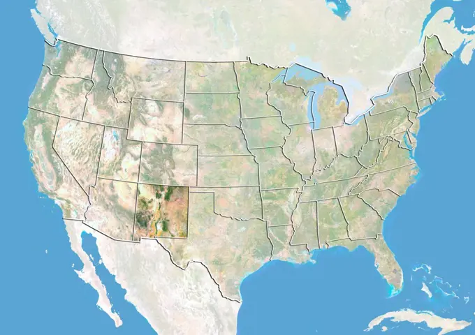
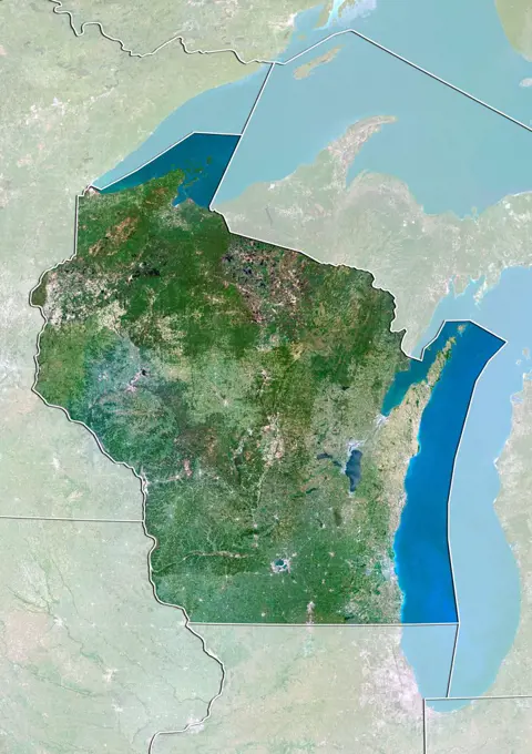
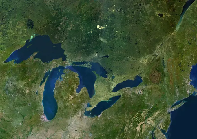
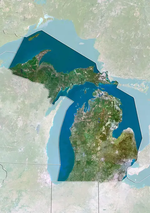
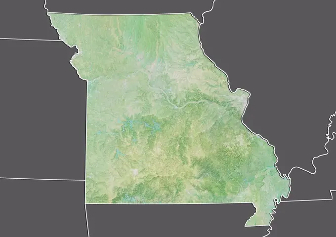
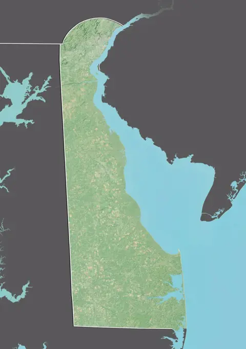
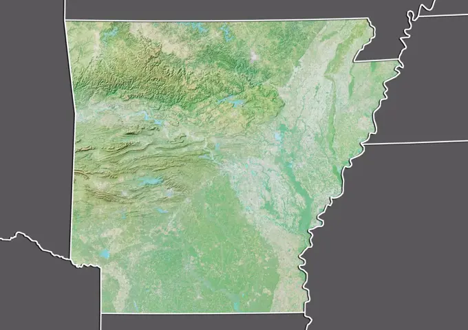
Detailed satellite imagery showcasing various states in the U.S., including Wisconsin, Indiana, Michigan, and more, highlighting land features and terrain.

Satellite view of the United States showing the State of Georgia. This image was compiled from data acquired by LANDSAT 5 & 7 satellites.
194 assets in this story
1899-81275
Satellite view of the United States with bump effect, showing the State of New Mexico. This image was compiled from data acquired by LANDSAT 5 & 7 satellites combined with elevation data.
1899-80594
Relief map of Canada showing the province of New Brunswick. This image was compiled from data acquired by LANDSAT 5 & 7 satellites combined with elevation data.
1899-80591
Relief map of Canada showing the province of Manitoba. This image was compiled from data acquired by LANDSAT 5 & 7 satellites combined with elevation data.
1899-21289832
Satellite view of North America that shows Arctic ice cap (with country boundaries). This image was compiled from data acquired by Landsat 7 & 8 satellites.
1899-80364
Satellite view of The United States with Bump Effect (with border). This image was compiled from data acquired by LANDSAT 5 & 7 satellites.
1899-21289829
Satellite view of North America. This image was compiled from data acquired by Landsat 7 & 8 satellites.
1899-35882
United States (Alaska Incl.), True Colour Satellite Image With Mask. USA (Alaska incl.), true colour satellite image with mask. This image was compiled from data acquired by LANDSAT 5 & 7 satellites.
1899-21289837
Satellite view of North America (with country boundaries). This image was compiled from data acquired by Landsat 7 & 8 satellites.
1899-80621
Relief map of Canada with boundaries of provinces. This image was compiled from data acquired by LANDSAT 5 & 7 satellites combined with elevation data.
4128R-13763327
Earth from space in night. Computer illustration showing the Earth as viewed from space, centred over North America.
1899-80618
Relief map of Canada showing the territory of Yukon. This image was compiled from data acquired by LANDSAT 5 & 7 satellites combined with elevation data.
1899-80610
Satellite view of Canada with bump effect, showing the province of Ontario. This image was compiled from data acquired by LANDSAT 5 & 7 satellites combined with elevation data.
1899-80619
Satellite view of Canada with bump effect, showing the territory of Yukon. This image was compiled from data acquired by LANDSAT 5 & 7 satellites combined with elevation data.
1899-35465
North America With Major Rivers, True Colour Satellite Image. True colour satellite image of North America with major rivers. This image in Lambert Conformal Conic projection was compiled from data acquired by LANDSAT 5 & 7 satellites.
1899-80585
Relief map of Canada showing the province of Alberta. This image was compiled from data acquired by LANDSAT 5 & 7 satellites combined with elevation data.
1899-80606
Relief map of Canada showing the territory of Nunavut. This image was compiled from data acquired by LANDSAT 5 & 7 satellites combined with elevation data.
1899-21289835
Satellite view of North America in winter, with partial snow cover and Arctic ice cap (with country boundaries). This image was compiled from data acquired by Landsat 7 & 8 satellites.
1899-80592
Satellite view of Canada with bump effect, showing the province of Manitoba. This image was compiled from data acquired by LANDSAT 5 & 7 satellites combined with elevation data.
1899-80598
Satellite view of Canada with bump effect, showing the province of Newfoundland and Labrador. This image was compiled from data acquired by LANDSAT 5 & 7 satellites combined with elevation data.
4239R-20480148
This natural-color image of North America combines cloud-free data from over 500 Multi-angle Imaging SpectroRadiometer (MISR) orbits with shaded relief Digital Terrain Elevation models from the Shuttle Radar Topography Mission (SRTM) and other sources.  In addition to the contiguous United States, the full size image spans from British Columbia in the northwest to Newfoundland in the northeast, and extends eastward to the lonely Bermuda Islands and southward to the Bahamas, Cuba and Mexico. Drap
1899-35210
Canada, North America, True Colour Satellite Image With Border. Satellite view of Canada (with border). This image was compiled from data acquired by LANDSAT 5 & 7 satellites.
4239-57497820
Detailed Earth globe close-up of North America.
1899-81479
Satellite view of the State of New Jersey and Northeastern United States. This image was compiled from data acquired by LANDSAT 5 & 7 satellites.
1899-82245
Relief map of the State of Iowa, United States. This image was compiled from data acquired by LANDSAT 5 & 7 satellites combined with elevation data.
1899-81789
Relief map of Ontario, Canada. This image was compiled from data acquired by LANDSAT 5 & 7 satellites combined with elevation data.
1899-81472
Relief map of the State of Maryland and Northeastern United States. This image was compiled from data acquired by LANDSAT 5 & 7 satellites combined with elevation data.
1899-81480
Relief map of the State of New York and Northeastern United States. This image was compiled from data acquired by LANDSAT 5 & 7 satellites combined with elevation data.
1899-80607
Satellite view of Canada with bump effect, showing the territory of Nunavut. This image was compiled from data acquired by LANDSAT 5 & 7 satellites combined with elevation data.
1899-66734
Relief map of Canada (with border and mask). This image was compiled from data acquired by landsat 5 & 7 satellites combined with elevation data.
1899-79699
Satellite view of Canada with Bump Effect (with border and mask). This image was compiled from data acquired by LANDSAT 5 & 7 satellites.
1899-82276
Relief map of the State of Missouri, United States. This image was compiled from data acquired by LANDSAT 5 & 7 satellites combined with elevation data.
1899-82298
Satellite view of the State of New York, United States. This image was compiled from data acquired by LANDSAT 5 & 7 satellites.
1899-81475
Satellite view of the State of Massachusetts and Northeastern United States. This image was compiled from data acquired by LANDSAT 5 & 7 satellites.
1899-82350
Satellite view of the State of Wisconsin, United States. This image was compiled from data acquired by LANDSAT 5 & 7 satellites.
1899-79701
Satellite view of Canada (with border and mask). This image was compiled from data acquired by LANDSAT 5 & 7 satellites.
1899-82258
Relief map of the State of Maine, United States. This image was compiled from data acquired by LANDSAT 5 & 7 satellites combined with elevation data.
1899-80623
Satellite view of Canada with boundaries of provinces. This image was compiled from data acquired by LANDSAT 5 & 7 satellites.
1899-82348
Relief map of the State of Wisconsin, United States. This image was compiled from data acquired by LANDSAT 5 & 7 satellites combined with elevation data.
1899-34882
Great Lakes, Usa & Canada, True Colour Satellite Image. Satellite image of the American Great Lakes : lake Superior, Michigan, Huron, Erie and Ontario. This image was compiled from data acquired by LANDSAT 5 & 7 satellites.
1899-80608
Satellite view of Canada showing the territory of Nunavut. This image was compiled from data acquired by LANDSAT 5 & 7 satellites.
1899-80617
Satellite view of Canada showing the province of Saskatchewan. This image was compiled from data acquired by LANDSAT 5 & 7 satellites.
1899-82224
Relief map of the State of Connecticut, United States. This image was compiled from data acquired by LANDSAT 5 & 7 satellites combined with elevation data.
1899-82259
Satellite view of the State of Maine, United States. This image was compiled from data acquired by LANDSAT 5 & 7 satellites.
1899-82300
Relief map of the State of North Carolina, United States. This image was compiled from data acquired by LANDSAT 5 & 7 satellites combined with elevation data.
1899-81777
Relief map of Newfoundland and Labrador, Canada. This image was compiled from data acquired by LANDSAT 5 & 7 satellites combined with elevation data.
1899-80614
Satellite view of Canada showing the province of Quebec. This image was compiled from data acquired by LANDSAT 5 & 7 satellites.
1899-66874
Relief map of Ontario, Canada. This image was compiled from data acquired by LANDSAT 5 & 7 satellites combined with elevation data.
1899-35470
North America At Night, True Colour Satellite Image. True colour satellite image of North America at night. This image in Lambert Conformal Conic projection was compiled from data acquired by LANDSAT 5 & 7 satellites.
1899-82265
Satellite view of the State of Massachusetts, United States. This image was compiled from data acquired by LANDSAT 5 & 7 satellites.
1899-82268
Satellite view of the State of Michigan, United States. This image was compiled from data acquired by LANDSAT 5 & 7 satellites.
1899-82225
Relief map of the State of Connecticut, United States. This image was compiled from data acquired by LANDSAT 5 & 7 satellites combined with elevation data.
6145-44968613
Amazing the things you can 'see' from space, if you just know how to look ... Satellite data show that during the Northern Hemisphere's growing season, the U.S. Midwest boasts more photosynthetic activity than any other spot on Earth. The magnitude of fluorescence portrayed in this visualization prompted researchers to take a closer look at the productivity of the U.S. Corn Belt. The glow represents fluorescence measured from land plants in early July, over a period from 2007 to 2011.
6177-V63505599
1899-82261
Relief map of the State of Maryland, United States. This image was compiled from data acquired by LANDSAT 5 & 7 satellites combined with elevation data.
1899-80481
Relief map of Australia showing the State of Queensland. This image was compiled from data acquired by LANDSAT 5 & 7 satellites combined with elevation data.
1899-82219
Relief map of the State of California, United States. This image was compiled from data acquired by LANDSAT 5 & 7 satellites combined with elevation data.
1899-82305
Relief map of the State of Ohio, United States. This image was compiled from data acquired by LANDSAT 5 & 7 satellites combined with elevation data.
4239R-20480240
Satellite view of The Great Lakes.
6177-V53618524
1899-66971
Relief map of the State of Missouri, United States. This image was compiled from data acquired by LANDSAT 5 & 7 satellites combined with elevation data.
1899-82275
Relief map of the State of Missouri, United States. This image was compiled from data acquired by LANDSAT 5 & 7 satellites combined with elevation data.
1899-66960
Relief map of the State of Illinois, United States. This image was compiled from data acquired by LANDSAT 5 & 7 satellites combined with elevation data.
1899-80051
Relief map of Mali (with border and mask). This image was compiled from data acquired by landsat 5 & 7 satellites combined with elevation data.
1899-82243
Relief map of the State of Indiana, United States. This image was compiled from data acquired by LANDSAT 5 & 7 satellites combined with elevation data.
1899-21290152
US East Coast at night in 2012, from Boston, Massachusetts down to Houston, Texas. This satellite image shows urban and industrial lights.
6145-45261734
City lights shine brighter during the holidays in the United States when compared with the rest of the year, as shown using a new analysis of daily data from the NASA-NOAA Suomi NPP satellite. Dark green pixels are areas where lights are 50 percent brighter, or more, during December. Because snow reflects so much light, the researchers could only analyze snow-free cities. They focused on the U.S. West Coast from San Francisco and Los Angeles, and cities south of a rough imaginary line from St. Louis to Washington, D.C.
1899-66956
Relief map of the State of Delaware, United States. This image was compiled from data acquired by LANDSAT 5 & 7 satellites combined with elevation data.
1899-66979
Relief map of the State of North Carolina, United States. This image was compiled from data acquired by LANDSAT 5 & 7 satellites combined with elevation data.
6177-V54021711
1899-21290010
Satellite view of Northeastern United States (with administrative boundaries). This image was compiled from data acquired by Landsat satellites.
6145-52083165
A satellite photo taken at night, showing visible light images of the major cities of the United States. Base: Vandenberg Air Force Base State: California (CA) Country: United States Of America (USA)
1899-82306
Relief map of the State of Ohio, United States. This image was compiled from data acquired by LANDSAT 5 & 7 satellites combined with elevation data.
1899-66839
Relief map of Sudan (with border and mask). This image was compiled from data acquired by landsat 5 & 7 satellites combined with elevation data.
6176-62007470
Demographic maps of different immigrant population density from different countries (Canadians, British, Irish, German and Scandanavian), Immigration
4409-28578184
Physical and political map of Canada. Encapsulated Postscript File (.eps); 2480x3507.
6145-50571538
Temperature chart of the United States : showing the distribution by isothermal curves of the mean annual temperature of the lower atmosphere , United States, Maps, Atmospheric temperature, United States, Maps Norman B. Leventhal Map Center Collection
4128-15982272
A comparison of Valles Marineris - the Solar System's largest known canyon, on Mars - with the United States of America. The Grand Canyon is but a scr...
6145-54372245
Tree Identification - Oak: Schumard. Photographs Relating to National Forests, Resource Management Practices, Personnel, and Cultural and Economic History
6145-54372699
Tree Identification - Locust. Photographs Relating to National Forests, Resource Management Practices, Personnel, and Cultural and Economic History
6145-54373984
Tree Identification - Ash. Photographs Relating to National Forests, Resource Management Practices, Personnel, and Cultural and Economic History
6145-55913470
Distribution of the magnetic declination in the United States in 1900. Relief shown by contours. In upper right: Seventeenth annual report, part. I, pl. II.... , United States
1899-66952
Relief map of the State of Arkansas, United States. This image was compiled from data acquired by LANDSAT 5 & 7 satellites combined with elevation data.
6145-54373103
Tree Identification - Fir- White. Photographs Relating to National Forests, Resource Management Practices, Personnel, and Cultural and Economic History
6145-54372954
Tree Identification - Holly. Photographs Relating to National Forests, Resource Management Practices, Personnel, and Cultural and Economic History
4197-62718920
Earth, satellite and landscape, map of world and Antarctica with clouds in atmosphere, water and snow in environment or nature. Aerial view, continent and terrain, ocean or sea of planet from space
6145-44769654
Data from JPL's Advanced Spaceborne Thermal Emission and Reflection Radiometer instrument on NASA's Terra satellite provides views of the L.A. Basin, San Francisco Bay and more.
6145-51992125
Earthquake - Ill. , April 15, 2011   Caption: US earthquake fault lines and risk predictions. Photo: US Geological Survey.. Photographs Relating to Disasters and Emergency Management Programs, Activities, and Officials
6145-54371263
Tree Identification - Popular. Photographs Relating to National Forests, Resource Management Practices, Personnel, and Cultural and Economic History
1899-82338
Relief map of the State of Virginia, United States. This image was compiled from data acquired by LANDSAT 5 & 7 satellites combined with elevation data.
6145-54372126
Tree Identification - Oak: Turkey. Photographs Relating to National Forests, Resource Management Practices, Personnel, and Cultural and Economic History
6188-64570242
Karte von Washington mit Anzeiger für Vulkan - Map of Washington with volcano locator Karte von Washington mit Anzeiger für Vulkan - Map of Washington with volcano locator Copyright: xZoonar.com/lantapixx 14295871
6145-44720886
Art Concept of the End-of-Mission Approach and Landing at WSTF, NM, from Rockwell. 1. ART CONCEPT - STS-3 LANDING 2. STS-3 - LANDING WSTF, NM Also available in 4x5 B&W
6145-51929790
United States bee colonies. "Data source: USDA National Agricultural Statistics Service."... , United States
6145-43861299
United States bee colonies , Honeybee, United States, Maps, United States, Maps Norman B. Leventhal Map Center Collection
PREVIOUS
of 2
NEXT
2401 S. Ervay, Suite 206
Dallas, Texas 75215
United States
Get Started
Free ResearchMy BoardsMy Cart
For Creators
How To License Your ContentContributor PortalFrame of Mind
Resources
API accessPricing
Contact
+1 866 236 0087help@viewpictures.co.uk Contact form
©2026 View Pictures. All Rights Reserved. -A
This site is protected by reCAPTCHA and Google Privacy Policy and Terms of Service apply.