My Boards
View Pictures
  • My Boards
← Documents & Records

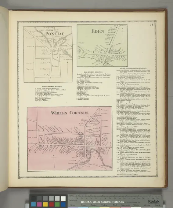
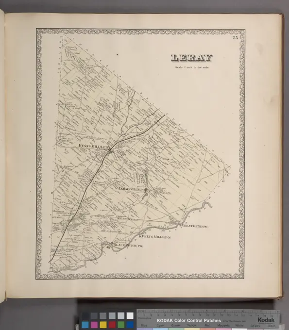
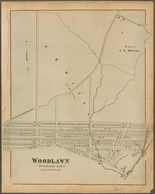
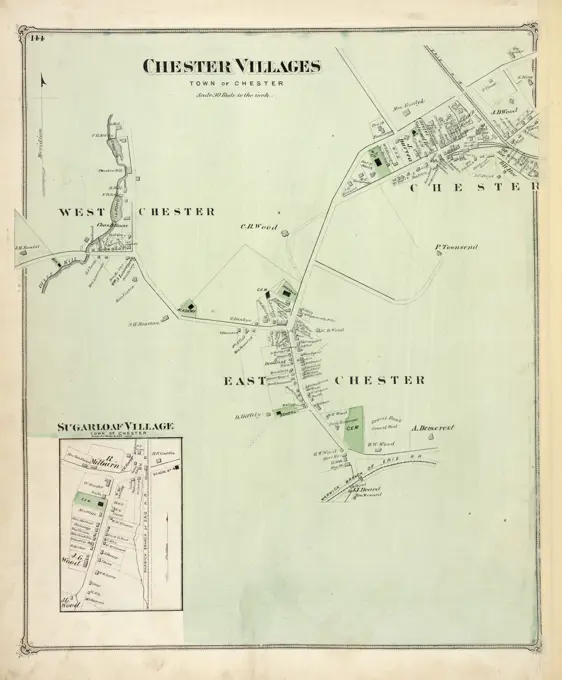
Town Maps of Massachusetts

Historic maps showcasing town layouts and landmarks in Massachusetts, highlighting details of urban planning and land use from the 19th century.

Plan of Boston with parts of the adjacent towns. Relief shown by hachures. Includes population statistics. Map is bordered by twenty finely rendered views of important public and business buildings.... , Massachusetts  , Suffolk  ,county   , Boston
Plan of Boston with parts of the adjacent towns. Relief shown by hachures. Includes population statistics. Map is bordered by twenty finely rendered views of important public and business buildings.... , Massachusetts , Suffolk ,county , Boston
273 assets in this story
6145-50551503
The Long Trail of the Green Mountain Club : Monroe Skyline Section : Bolton to Montclair Glen-Trails to Couching Lion , Trails, Vermont, Maps, Hiking, Vermont, Maps, Long Trail Vt., Maps Norman B. Leventhal Map Center Collection
6145-51398398
Plan du port et de la ville de Boulogne , Navigation, France, Boulogne-sur-Mer, Harbors, France, Boulogne-sur-Mer, Maps, Boulogne-sur-Mer France, Maps Norman B. Leventhal Map Center Collection
6145-59474706
Map of the Graafschap Holland and Utrecht (plate 35), Jacob Aertsz. Colom (I), 1639 print   paper etching / engraving maps, atlases Amersfoort. Utrecht
6145-59245183
Map with the Dutch forts on the Scheldt, 1747, 1747 print Map with the siege of the Dutch Forts Frederik Hendrik, Lillo, Kruischans and Liefkenshoek, located on the Scheldt, by the French between 1 and 14 October 1747, and the inundated areas. With inscriptions in pen in the show. On the leaf under the plate a description of the forts in two columns. print maker: Northern Netherlandspublisher: The Hague paper etching / letterpress printing maps of separate countries or regions. fortress Scheldt. Fort Lillo. Fort Liefkenshoek
6145-50651937
Province of Utrecht Municipality of Baambrugge
6145-48719837
The Long Trail of the Green Mountain Club : Monroe Skyline Section : Bolton to Montclair Glen-Trails to Couching Lion , Trails, Vermont, Maps, Hiking, Vermont, Maps, Long Trail Vt., Maps Norman B. Leventhal Map Center Collection
6145-43861064
Richmond and its defences : constructed and engraved to illustrate 'The war with the South' , Fortification, Virginia, Richmond, Maps, Richmond Va., History, Civil War, 1861-1865, Maps Norman B. Leventhal Map Center Collection
6145-55914456
Map of East Bridgewater, Mass.... , Massachusetts  , Plymouth  ,county   , East Bridgewater
6145-48448587
Jansen Hermann (1869-1945), development plan Berlin-Gatow and Berlin-Kladow: military facility, surveying card in 4 parts, southeastern part 1: 4000. Ink, pencil and colored pencil over a break on transparent, 126.50 x 82.50 cm (including scan edge). Architecture Museum of the Technical University of Berlin Inv. No. 22499. Jansen Hermann  (1869-1945): Bebauungsplan Berlin-Gatow und Berlin-Kladow
6145-54549113
Pontlac Village; Pontlac Business Directory.; Eden Village; Eden Business Directory.; Whites Corners Business Directory. Whites Corners Village Cartographic. Atlases, Maps. 1866. Lionel Pincus and Princess Firyal Map Division. Erie County (N.Y.)
6145-43861050
Plan of Sesuit Harbor in East Dennis : under chapter 32 resolves of 1907 , East Dennis Mass., Maps, Harbors, Massachusetts, East Dennis, Maps Norman B. Leventhal Map Center Collection
4443-75467969
Plan of the operations of General Washington against the King's troops in New Jersey, covering the period from December 26, 1776, to January 3, 1777. The map, published in London by Wm. Faden on April 15, 1777, is hand-colored and measures 29 x 39 cm. The NYPL copy is trimmed and matted with paper, lacking margins and the imprint. It highlights significant events in the New Jersey campaign during the American Revolution, including the Battles of Princeton and Trenton
6145-30279169
Palm Schoß near Brixen, Construction area of the Palmschoos near Brixen, Otto Wagner -, artist
6145-54269404
Taunton. Insets: Myrickville, East Taunton, Westville, and Ward 4. Appears in F.W. Beers "Atlas of Bristol Co. Massachusetts", 1871.... , Massachusetts  , Bristol  ,county   , Taunton
6145-50523534
Topographical map of the District of Columbia , Washington D.C., Maps Norman B. Leventhal Map Center Collection
6145-55957740
Map of Shelter Island showing location of roads & building: compiled partly from county map and actual surveys Cartographic. Maps, Manuscript maps. 1889. Lionel Pincus and Princess Firyal Map Division. Real property , New York (State) , Shelter Island (N.Y.), Shelter Island (N.Y.)
6145-55955216
Map of Niagara Falls, suspension bridge, and vicinity Cartographic. Maps. 1885. Lionel Pincus and Princess Firyal Map Division. Niagara Falls Suspension Bridge Company, Niagara Falls (N.Y.), Niagara Falls (Ont.), Niagara River Valley (N.Y. and Ont.), New York (State) , Niagara Falls (N.Y.), North America , Niagara River Valley (N.Y. and Ont.), Ontario , Niagara Falls (Ont.)
4443-75462351
Map of the Clinton County Coal Company in Clinton County, Pennsylvania, created between 1855 and 1856. The map, measuring 45 x 51 cm on a sheet of 50 x 54 cm, details railroads, canals, and coal mines in the Middle Atlantic States. The publisher is not identified
6145-55176862
Cartographic, Maps. 1873. Lionel Pincus and Princess Firyal Map Division. Long Island (N.Y.) , Description and travel New Bridge & vicinity, Town of Hempstead, Queens Co.
6145-50444327
Jansen Hermann (1869-1945), Building Plan Munich-Hirschau (12.05.1932): Variant 7 A: Department 1: 5000. Colored pencil over a break on paper, 39.1 x 39.7 cm (including scan edges) Jansen Hermann  (1869-1945): Bebauungsplan München-Hirschau
6145-50511350
Plan of Groton, Massachusetts : as it was in 1794 , Manuscript maps, Early works to 1800, Facsimiles, Groton Mass. : Town, Maps, Manuscript, Early works to 1800, Facsimiles, Pepperell Mass. : Town, Maps, Manuscript, Early works to 1800, Facsimiles, Shirley Mass. : Town, Maps, Manuscript, Early works to 1800, Facsimiles, Massachusetts, Boundaries, Maps, Manuscript, Early works to 1800, Facsimiles Norman B. Leventhal Map Center Collection
6145-54268648
Plan of Groton, Massachusetts : as it was in 1794. Shows boundaries of the towns of Groton, Pepperrell, and Shirley. Facsim. of a ms. map. "Jan. 15, 1894." "Reduced one third from the original manuscript at the State House." Oriented with north toward the upper right. Includes text. Reproduction of: This plan contains the bounds of three towns, viz. Groton, Pepperell & Shirley, 1794. in the Massachusetts State House.... , Massachusetts  , Middlesex  ,county   , Groton Massachusetts  , Middlesex  ,county   , Pepperell Massachusetts  , Middlesex  ,county   , Shirley
4443-75473213
Chester, survey of 1894, ed. of 1898, repr. 1906. Geological Survey (U.S.)., 1899 - 1926 ., Washington. Publisher, The Survey, New Jersey. Maps
6145-54268145
Berkley Co., W. Va. Title and scale added in manuscript pencil. Part of a collection of maps of West Virginia counties... Berkeley Co., W. Va. Berkeley Co., W. Va, West Virginia  , Berkeley  ,county
4443-75458962
Map of the Sea-Coast of South Carolina showing the depth of water on each bar, 1861-11-30. Additional, Map of the Sea Coast of South Carolina., 1861-11-30., New York, N.Y. Publisher, Harper's Weekly., 1 map; 36 x 16 cm on sheet 40 x 29 cm. Topics include Islands, Coasts, Sea Islands, Beaufort (S.C.), History, and Civil War (1861-1865) related to Port Royal (S.C.)
6145-48559308
Plan of Boston showing existing ways and owners on December 25, 1635 , Homeowners, Massachusetts, Boston, Maps, Landowners, Massachusetts, Boston, Maps, Boston Mass., History, Colonial period, ca. 1600-1775, Maps Norman B. Leventhal Map Center Collection
6145-50567430
Battlefield of Chattanooga with the operations of the national forces under the command of Maj. Gen. U.S. Grant during the battles of Nov. 23, 24, & 25, 1863 , Chattanooga, Battle of, Chattanooga, Tenn., 1863, Maps, Landowners, Tennessee, Chattanooga, Maps Norman B. Leventhal Map Center Collection
6145-54267535
Forest map of the Yakima Region, Washington Ter. showing the predominant elements of the forest covering. Relief shown by contours and spot heights. "Western sheet."--upper margin. Series title on map: Forest bulletin, no. 1.... , Washington  , Yakima  ,river
6145-48718758
Plan of Groton, Massachusetts : as it was in 1794 , Manuscript maps, Early works to 1800, Facsimiles, Groton Mass. : Town, Maps, Manuscript, Early works to 1800, Facsimiles, Pepperell Mass. : Town, Maps, Manuscript, Early works to 1800, Facsimiles, Shirley Mass. : Town, Maps, Manuscript, Early works to 1800, Facsimiles, Massachusetts, Boundaries, Maps, Manuscript, Early works to 1800, Facsimiles Norman B. Leventhal Map Center Collection
6145-50574399
Plan of Abington made by James Bates, dated 1830 ,. Massachusetts. Office of the Secretary of State
6145-50519181
Sketch map of Boston and the Public Library system , Boston Public Library, Libraries, Massachusetts, Boston, Maps, Boston Mass., Maps Norman B. Leventhal Map Center Collection
6176-66904006
Battle-field of Chickamauga, Shows roads, fords, drainage, vegetation, houses, names of residents, fences, and relief by contour lines. Some fortifications are given but troop positions and movements during the Battle of Chickamauga are not indicated.
6145-54267644
Hydrographic map of the Chain-O'-Lakes, Waupaca Co. Wis.. Depths shown by hypsometric tints, bathymetric isolines and soundings. Includes statistics. "Contour intervals 10 feet." At head of cover title: no. 5. Explanation of map on inside of front cover. Imprint from cover... Hydrographic map of the Chain-O'-Lakes, Waupaca County, Wis.. Hydrographic map of the Chain-O'-Lakes, Waupaca County, Wis., Wisconsin  , Waupaca  ,county   , Chain O Lakes
6145-48719241
Map of Boston postal stations , Postal service, Massachusetts, Boston, Maps, Boston Mass., Maps Norman B. Leventhal Map Center Collection
6145-48446919
Jansen Hermann (1869-1945), Hagen development plan (24.08.1931): Worksheet basic map with altitude lines, department 233, sheet 22 1: 2000. Lithograph on paper, 74.7 x 101.4 cm (including scan edges) Jansen Hermann  (1869-1945): Hagen Bebauungsplan
6145-48446936
Jansen Hermann (1869-1945), Hagen development plan (1931-1931): Worksheet basic map without altitude lines, department 232, sheet 16 1: 2000. Lithograph on paper, 76.4 x 101.4 cm (including scan edges) Jansen Hermann  (1869-1945): Hagen Bebauungsplan
6145-48712768
Plan of Abington made by James Bates, dated 1830 ,. Massachusetts. Office of the Secretary of State
6145-50511195
Plan of C. H. Campbell's farm in Wayland, Mass. , History, Farms, Campbell, Charles H., 1823-1894, Heard, William, 1795-1869. Wayland Historical Maps and Plans
6145-54549414
Chatham Village Village; Chatham Village Business Notices Bourquin, F. (Frederick), 1808-. Cartographic. Atlases, Maps. 1873. Lionel Pincus and Princess Firyal Map Division. Columbia County (N.Y.), Real property , New York (State) , Columbia County, Business enterprises , New York (State) , Columbia County
6145-54549471
Leray Township Cartographic. Atlases, Maps. 1864. Lionel Pincus and Princess Firyal Map Division. Jefferson County (N.Y.), Real property , New York (State)
6176-66918803
Map of the siege and investment of Savannah, Georgia, 5th to 20th December 1864. USA Civil War
4443-21864178
Location map of Lydda aerodrome. 1934, Israel, Lod
6145-46417477
Map of Antwerp and the Citadel, 1832; Plan of Antwerp and the Citadel. Map of Antwerp and the Citadel, at the time of the Siege of Antwerp in December 1832.
6145-54269459
Traffic for Birkenhead. Oriented with north towards the upper left. Includes text and references. Names for correspondence crossed out and corrected in manuscript ink: James Leather corrected to George Wilkins and James Pinion corrected to J.E. Charnley... Cheshire Lines Committee, consisting of the Great Northern, Great Central, and Midland Railways. Cheshire Lines Committee, consisting of the Great Northern, Great Central, and Midland Railways, England  , Wirral  ,county   , Birkenhead
6145-48719400
Atlas of the county of Suffolk, Massachusetts : vol. 3rd including Boston and Dorchester : from actual surveys and official records : plate R , Real property, Massachusetts, Boston, Maps, Landowners, Massachusetts, Boston, Maps, Dorchester Boston, Mass., Maps Norman B. Leventhal Map Center Collection
6145-59334622
Coronation Stone in Kingston-upon-Thames, Henry W. Taunt, 1871 photograph  Kingston-upon-Thames photographic support albumen print monument, statue Kingston-upon-Thames
4435-8749
Spain. Peninsular War (1808-1814). Map of the first siege of Saragossa (June 1808). From the work 'Atlas de la Guerra de Independencia' (1868). SPAIN. MADRID (AUTONOMOUS COMMUNITY). Madrid. National Library.
4443-73140489
The, Auk, Washington, D.C, American, Ornithologists', Union, 1884, birds, periodicals, A topographic map of Gallatin County, Montana, showcasing the region's mountainous terrain and various geographic features. The map outlines significant landmarks including the Gallatin River, several lakes, and forested areas, while also indicating boundaries for nearby national parks. Key towns and geographic divisions are labeled, providing a clear representation of the area's layout and topography, which includes elevations and contour lines that illustrate the land's elevation changes. The map serves as both a navigational tool and a historical reference to the region's landscape.
6145-55181178
Liberty Village; Cohocton Business Notices; North Cohocton Business Notices; North Cohocton Village Cartographic. Atlases, Maps. 1873. Lionel Pincus and Princess Firyal Map Division. Steuben County (N.Y.), Real property , New York (State) , Steuben County, Business enterprises , New York (State) , Steuben County
6176-66915876
Map of Siege of Mantua - During the Siege of Mantua, which lasted from 4 July 1796 to 2 February 1797 with a short break, French forces under the overall command of Napoleon Bonaparte besieged and blockaded a large Austrian garrison at Mantua for many months until it surrendered.
6145-55181349
Tyrone Village; Altay Village; Town of Tyrone Business Directory; Weston Village Cartographic. Atlases, Maps. 1874. Lionel Pincus and Princess Firyal Map Division. Schuyler County (N.Y.), New York (State) , Schuyler County
6145-50567231
Brooke Co., West Virginia , Brooke County W. Va., Maps Norman B. Leventhal Map Center Collection
6145-45721249
Map of the west coast of Flanders between Ostend and Nieuwpoort, 1600; Explanation of the history of the campaign in Flanders and the Battle of Nieuwpoort Ao. 1600. Map of the West Coast of Flanders between Ostend and Nieuwpoort, to illustrate the trip to Ostend of the State Army among Maurits, 19-27 June, 1600. With the board of the road from Philippine to Oudenburg.
6145-55176947
Cartographic, Maps. 1873. Lionel Pincus and Princess Firyal Map Division. Long Island (N.Y.) , Description and travel Maspeth. Town of Newtown, Queens Co. - East Williamsburgh. Town of Newtown, Queens Co. L.I. - Woodside. Tn. of Newtown, Queens Co. East Williamsburgh. Woodside.
6145-44213835
Messtischblatt 1385 = 226 : Pillau, 1908
4443-75476934
New Haven Business Directory; New Haven Village; New Haven Township, 1867. Issued by C. K. Stone in Philadelphia. Focuses on real property and business enterprises in Oswego County, New York
6145-52359636
Plate 81: Woodlawn, Westchester Co. N.Y. Cartographic. Atlases, Maps. 1872. Lionel Pincus and Princess Firyal Map Division. Westchester County (N.Y.), Real property , New York (State) , Westchester County
4220-2961
Map of the Canal : note thatthe Atlantic is on the left,the Pacific on the right,because the canal actuallyruns from NW to SE - Panamais east of Colon. Date: circa 1890
6145-48447778
Jansen Hermann (1869-1945), total development plan Ankara. Surroundings of Ankara (February 20, 1937): Overview plan 1: 5000. Light break on paper, 59 x 96.2 cm (including scan edges) Jansen Hermann  (1869-1945): Gesamtbebauungsplan Ankara. Umgebung von Ankara
6145-55958725
Map of the Adirondacks, as reached by the Delaware and Hudson Canal Companys Railroad Cartographic. Maps. 1880. Lionel Pincus and Princess Firyal Map Division. Delaware and Hudson Canal Company, Railroads , New York (State) , Adirondack Mountains (N.Y.), Adirondack Mountains (N.Y.)
6145-48926831
Map of the District Affected by the Tarawera Eruption
6145-55957699
Chester Villages Village; Sugarloaf Village Village Cartographic. Atlases, Maps. 1875. Lionel Pincus and Princess Firyal Map Division. Orange County (N.Y.), Real property , New York (State) , Orange County, Orange County (N.Y.) , History, Business enterprises , New York (State) , Orange County
6145-30259621
Surroundings of Vienna sheet , Klosterneuburg, Pötzleinsdorf, Military Geographic Institute -, editor
6145-54548904
The Hudson by daylight map, from New York Bay to the head of tide water : containing names of streams, islands, and heights of mountains according to the latest coast survey : also the names of prominent residences, historic land marks, the old reaches of the Hudson, and old Indian names. Cartographic. Maps. 1878. Lionel Pincus and Princess Firyal Map Division. Hudson River (N.Y. and N.J.) , Maps, Hudson River Valley (N.Y. and N.J.) , Maps
6145-48827159
City plans of Saxon cities with statistical information on the cholera victims of 1865, before 1866
6145-59307687
Fortress map of Zwartsluis, Anonymous, c. 1650 - c. 1799 drawing On the right a bowl: range of 30 rods.  parchment (animal material). watercolor (paint). ink brush / pen maps of cities. fortress Blacksluis
6145-50511815
Plan of the highway in Rockport, Mass., from Rail-road Avenue to Samuel Parker's , Streets
6145-48448577
Jansen Hermann (1869-1945), development plan Bad Segeberg (20.08.1927): Department of Northwest and southwestern part 1: 2500. Pressure on cardboard, 111.7 x 89.4 cm (including scan edges) Jansen Hermann  (1869-1945): Bebauungsplan Bad Segeberg
6145-52359795
Potsdam Village Village; Potsdam Business Directory. Cartographic. Atlases, Maps. 1865. Lionel Pincus and Princess Firyal Map Division. Saint Lawrence County (N.Y.), Real property , New York (State) , Saint Lawrence County
4443-75473354
Canton Village Directory, 1865, by S. N. Beers. Published in Philadelphia, Saint Lawrence County, New York. Topics include real property in New York State and Saint Lawrence County
6145-55958037
Cayuga County, Right Page Map town of Summer Hill Cartographic. Atlases, Maps. 1904. Lionel Pincus and Princess Firyal Map Division. Real property , New York (State) , Herkimer County, Herkimer County (N.Y.) , Description and travel
6145-48445687
Jansen Hermann (1869-1945), Hagen development plan (07/27/1932): Baustufenplan Stadt Hagen 1: 2000 part D. Light break on cardboard, 136.1 x 105.8 cm (including scan edges) Jansen Hermann  (1869-1945): Hagen Bebauungsplan
6145-48445685
Jansen Hermann (1869-1945), Hagen development plan (July 27, 1932): Construction stage city Hagen 1: 2000 part D. Break break on cardboard, 136.7 x 105.9 cm (including scan edges) Jansen Hermann  (1869-1945): Hagen Bebauungsplan
PREVIOUS
of 3
NEXT
2401 S. Ervay, Suite 206
Dallas, Texas 75215
United States
Get Started
Free ResearchMy BoardsMy Cart
For Creators
How To License Your ContentContributor PortalFrame of Mind
Resources
API accessPricing
Contact
+1 866 236 0087help@viewpictures.co.uk Contact form
©2026 View Pictures. All Rights Reserved. -B
This site is protected by reCAPTCHA and Google Privacy Policy and Terms of Service apply.