My Boards
View Pictures
  • My Boards
← Environment / Sustainability

Hurricane Katrina Aerial Views

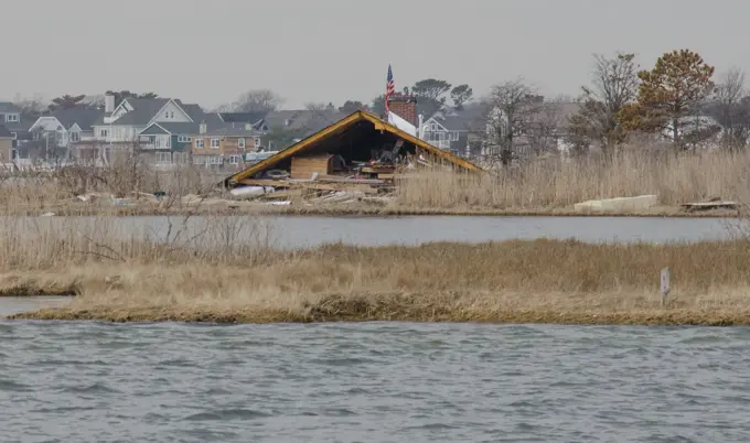
Aerial photographs showing the devastation from Hurricane Katrina, including flooded areas, damaged infrastructure, and environmental impacts in affected regions.

Dolphin Rescue - 26-HK-130-401. Hurricane Katrina
167 assets in this story
6145-52073380
Disaster Assistance Response Teams (DART) - Marine Safety Office St. Louis - 26-HK-123-6. Hurricane Katrina
6145-54338415
Office of the Administrator (Lisa P. Jackson) - ASPECT Flight over Gulfport, Mississippi (BP Oil Spill) - USEPA photo by Eric Vance , Environmental Protection Agency
6145-52076270
Pollution - ESU St. Louis Response - Murphy Oil - 26-HK-242-65. Hurricane Katrina
6145-54403277
Miscellaneous - Katrina and Rita - 26-HK-431-107. Hurricane Katrina
6145-54322971
Severe Storms/Flooding,  Grand Forks, ND, May 17, 2006   Aerial view of the south end of Grand Forks mitigation project building new levee walls, burns and pumping stations protecting the city from the Red River.. Photographs Relating to Disasters and Emergency Management Programs, Activities, and Officials
6145-54317144
Severe Storms/Flooding,  Grand Forks, ND, May, 1997   Aerial view of Grand Forks and the flooded Red River of the North and a levee that was toped with sandbags and breeched, flooding a neighborhood near the river.  .. Photographs Relating to Disasters and Emergency Management Programs, Activities, and Officials
6145-52074985
Disaster Assistance Response Teams (DART) - Marine Safety Office St. Louis - 26-HK-120-170. Hurricane Katrina
6162-75539076
Aerial view of a stark contrast between urban development and raw nature, divided by canals and roadways, Coral Springs, Florida, United States.
6145-54405296
Dolphin Rescue - 26-HK-130-88. Hurricane Katrina
6145-52063110
New Orleans Gunlock Photos - 26-HK-331-52. Hurricane Katrina
6145-52081585
Aftermath - New Orleans and Surrounding Areas - 26-HK-286-40. Hurricane Katrina
6145-54405303
Dolphin Rescue - 26-HK-130-96. Hurricane Katrina
6145-54324617
Hurricane Katrina, New Orleans, LA, September 4, 2005 -- Neighborhoods and roadways remain flooded as a result of Hurricane Katrina. Jocelyn Augustino/FEMA
6145-48900918
An aerial view of the flooding at the Camp Ashland, Nebraska on March 17, 2019. The levee to the north of the camp broke and water from the swollen Platte River poured thousands of gallons of water into the low-lying area trapping vehicles on the high ground and damaging buildings. Nebraska has experienced its worst flooding ever; displacing hundreds of people and causing millions of dollars in damages to homes, farmland, and cities. (Nebraska National Guard
6145-54403289
Miscellaneous - Katrina and Rita - 26-HK-431-120. Hurricane Katrina
6145-52079683
Aftermath - Flooding - Miscellaneous - 26-HK-36-213. aerial view of residential area with bridge in distance. Hurricane Katrina
6145-54617287
Visit of Secretary Dirk Kempthorne and aides to the Louisiana coast for Shell Oil briefing on offshore energy production, tour of offshore platform, fly-over of New Orleans and surrounding areas. Joining the Interior delegation for the offshore tour were Louisiana Senator Mary Landrieu and Congressman Bobby Jindal.
6145-52066248
Pollution - ESU St. Louis Response - Shell Pilottown - 26-HK-246-64. OVERVIEW OF O W. Hurricane Katrina
6145-52061817
Overflight - Potter - Pilottown and North - 26-HK-211-41. 29 16.089N 089 21.397W; Various pics IVO Pilot Town. Hurricane Katrina
6145-52073573
Disaster Assistance Response Teams (DART) - Marine Safety Office St. Louis - 26-HK-123-8. Hurricane Katrina
6145-52079539
ESU St. Louis - Assessment - 26-HK-316-49. Hurricane Katrina
6145-52080084
Aftermath - Waveland and Pass Christian, Mississippi - 26-HK-284-16. Hurricane Katrina
6145-54109875
Unsupported rails span a creek after the Road 702 wildfire burned the substructure of a bridge days earlier, as seen May 3, 2022, near Cambridge, Nebraska. Thirty-four National Guard Airmen and Soldiers assisted local firefighters with air and ground firefighting assets and helped tame the wildfire that burned more than 40,000 acres near the Kansas-Nebraska border.
6145-54404244
Vice Admiral Thad Allen Aerial Tour of Hancock County, Mississippi - 26-HK-20-11. Hurricane Katrina
6145-52059595
Aerial and Satellite Images - 26-HK-19-99. Hurricane Katrina
6145-54657373
Aerial views of California taken during visit of Acting Secretary P. Lynn Scarlett
6145-52014424
Office of Administration and Resource Management - Senior Executive Service (SES) training at the Gaylord National Resort and Convention Center, National Harbor, MD , Environmental Protection Agency
6145-54409433
Aftermath - Miscellaneous - Aerial - 26-HK-49-109. aerial view of destroyed community in densely wooded area3. Hurricane Katrina
6145-52081623
Aftermath - New Orleans and Surrounding Areas - 26-HK-286-53. Hurricane Katrina
6145-52065413
New Orleans - 26-HK-200-70. Hurricane Katrina
6145-54338476
Office of the Administrator (Lisa P. Jackson) - Various Images (BP Oil Spill) - Islands in the Chandeleur Island chain surrounded bt boom and sorbent boom.USEPA photo by Eric Vance , Environmental Protection Agency
6145-52081924
Pollution - ESU St. Louis Response - Murphy Oil - 26-HK-242-22. Overflight Assessment of Murphy. Hurricane Katrina
6145-54405240
Dolphin Rescue - 26-HK-130-27. Hurricane Katrina
6145-52080170
Aftermath - Miscellaneous - 26-HK-48-147. WI816D~1. Hurricane Katrina
6145-54660063
Aerial views of California taken during visit of Acting Secretary P. Lynn Scarlett
6145-54405294
Dolphin Rescue - 26-HK-130-86. Hurricane Katrina
6096-20061263
France, Maine-et-Loire, summer 2022. Aerial view of the drought and heat wave in Anjou, Maine et Loire, caused by global warming and climate change. Photograph by Martin Bertrand.France, Maine-et-Loire, ete 2022. Vue aerienne de la secheresse et de la canicule en Anjou dans le Maine et Loire entrainees par le rechauffement et le dereglement climatique. Photographie de Martin Bertrand.
6145-54316943
011032809  North Dakota Flooding. North Dakota Severe Storms and Flooding. Photographs Relating to Disasters and Emergency Management Programs, Activities, and Officials
6145-52065385
New Orleans - 26-HK-200-45. Hurricane Katrina
6145-54316862
Flooding - Minot, N. D. , June 26, 2011   Highway 52 from Velva to Minot was cut off due to flooding from the Souris River. Burleigh and Ward counties were designated a federal disaster area, opening the way for federal disaster assistance from FEMA. Andrea Booher/FEMA. North Dakota Flooding. Photographs Relating to Disasters and Emergency Management Programs, Activities, and Officials
6145-51987676
Mantoloking, N.J., Feb. 25, 2012   A rooftop landed in a marshy area in Barnegat Bay after blowing off a house during Hurricane Sandy. New Jersey Hurricane Sandy. Photographs Relating to Disasters and Emergency Management Programs, Activities, and Officials
6145-52062957
Critical Incident Stress Management - Gulfport from the Air - 26-HK-138-9. Hurricane Katrina
6145-54109882
Nebraska Army National Guard soldiers fly a UH-60 Black Hawk helicopter above Cambridge, Neb., May 3, 2022, carrying Nebraska Adjutant General, Maj. Gen. Daryl Bohac, and local officials observing damage from the recent Road 702 wildfire, which burned more than 40,000 acres. Residents of Cambridge were ordered to evacuate April 22 as the wildfire approached, fueled by drought conditions and winds in excess of 50 mph, but the path of the fire ultimately spared the town of 1,100 residents.
6145-52080188
Aftermath - Flooding - Miscellaneous - 26-HK-36-1. AE30B4~1. Hurricane Katrina
6145-52072213
Aftermath - Miscellaneous - Aerial - 26-HK-49-71. aerial view of damaged Sav-A-Center building with debris piled in lot, date stamped Nov 3 2005. Hurricane Katrina
6145-54312166
Hurricane Sandy damage Mantaloking. New Jersey Hurricane Sandy. Photographs Relating to Disasters and Emergency Management Programs, Activities, and Officials
6145-52925708
Aerial views of landscapes in Idaho, taken during visit of Secretary Dirk Kempthorne to the Boise National Forest area to observe the impact of the summer's Middle Fork Complex and Sheep Trail Fires
6145-54641379
Visit of Secretary Dirk Kempthorne to the Folsom Dam Overlook and surrounding area, Folsom, California, for tours, meetings with Bureau of Reclamation, U.S. Army Corps of Engineers and other personnel on the occasion of the groundbreaking ceremony for the Folsom Dam Joint Federal Project
6145-52081488
Aftermath - New Orleans and Surrounding Areas - 26-HK-286-21. Hurricane Katrina
6145-54319698
Severe Storms/Flooding,  Grand Forks, ND April 1, 1997 - Aerial of a Grand Forks neighborhood still flooded after the Red River came though town.  .. Photographs Relating to Disasters and Emergency Management Programs, Activities, and Officials
6162-78685574
Greensburg, United States - 08 March 2026: Aerial view of the vast industrial complex reflecting in the still waters of the adjacent pond, a stark contrast to the surrounding green fields.
6145-54659986
Aerial views of California taken during visit of Acting Secretary P. Lynn Scarlett
6145-52078201
Overflight - Baton Rouge - New Orleans - 26-HK-214-59. Hurricane Katrina
6145-54319377
Severe Storms/Flooding,  Grand Forks, ND, April 1, 1997 - Aerial of Grand Forks neighborhood still flooded after the Red River flood waters came though the town.  .. Photographs Relating to Disasters and Emergency Management Programs, Activities, and Officials
6145-54323022
Severe Storms/Flooding,  Grand Forks, ND, May 17, 2006   Aerial view of Grand Forks mitigation project building new levee walls, burns and pumping stations protecting the city from the Red River.. Photographs Relating to Disasters and Emergency Management Programs, Activities, and Officials
6145-54244431
South Carolina Gov. Henry McMaster visits the coastal areas of South Carolina most affected by Hurricane Ian aboard a South Carolina Army National Guard UH-60 helicopter assigned to 59th Aviation Troop Command, South Carolina, Oct. 1, 2022. The purpose of the flight was to allow Governor McMaster to assess the damage on the coast between the Blue River-North Myrtle Beach and Georgetown-Charleston areas, as well as to meet with local authorities and emergency responders. Hurricane Ian made landfall in the proximity of Georgetown, South Carolina, just after 2 p.m. on Friday, Sep. 30, 2022, as a category 1 hurricane. The storm continued moving North-Northwest bound and became a post-tropical cyclone by the evening of the same day. Ian caused an estimated total of sixty-seven deaths in Florida, four in North Carolina, and none in South Carolina. Total-casualties totals will remain subject to changes as rescue and recovery efforts continue in all three states. The South Carolina National Gu
6145-52071001
ESU St. Louis - Morgan City - 26-HK-376-66. Morgan City and Vicinity. Hurricane Katrina
6145-52081663
Salvage Engineering Response Team - New Orleans - Early October - 26-HK-350-33. Empire. Hurricane Katrina
6145-52077599
. Hurricane Katrina
6145-54485636
Aerials of the flooded town when the Mississippi River overran its banks after strong rain storms. Subject Operation/Series: MIDWEST FLOODS Base: Saint Genevieve State: Missouri (MO) Country: United States Of America (USA)
6145-52065415
New Orleans - 26-HK-200-72. Hurricane Katrina
6145-52065480
New Orleans - 26-HK-200-111. Hurricane Katrina
6145-54306688
Hurricane/Tropical Storm - Bridgeport, Conn. , September 1, 2011   An aerial view of Soudview Drive, shows some flooding that occurred due to Hurricane Irene. Bridgeport, CT-September 1, 2011-- lAn ariel view of Soudview Drive, shows some flooding that occurred due to Hurricane Irene.. Photographs Relating to Disasters and Emergency Management Programs, Activities, and Officials
6145-51993932
Flooding - Fargo, N. D. , March 24, 2009   US Coast Guard flyover to survey the Red River flooding. Photo: Michael Rieger/FEMA. North Dakota Severe Storms and Flooding. Photographs Relating to Disasters and Emergency Management Programs, Activities, and Officials
6145-54306692
Hurricane/Tropical Storm - East Haven, Conn. , September 1, 2011   CT-Flyover state of Connecticut with Cival Air Patrol on September 1, 2011. East Haven, CT-September 1, 2011-- An ariel view shows some damage incurred  due to Hurricane Irene.  Local crews work to repair areas impacted by the storm.. Photographs Relating to Disasters and Emergency Management Programs, Activities, and Officials
6188-60044581
Children recreational playground, playfull colors, climbing rack, slide and other attributes on a puzzle piece on water. Aerial drone view. Children recreational playground, playfull colors, climbing rack, slide and other attributes on a puzzle piece on water. Copyright: xZoonar.com/HugoxKurkx 21570079
6145-55969397
The U.S. Army Corps of Engineers Jacksonville District celebrated the completion of construction for the Herbert Hoover Restoration Project around Lake Okeechobee in Clewiston, Fla.  (USACE photo)
PREVIOUS
of 2
NEXT
2401 S. Ervay, Suite 206
Dallas, Texas 75215
United States
Get Started
Free ResearchMy BoardsMy Cart
For Creators
How To License Your ContentContributor PortalFrame of Mind
Resources
API accessPricing
Contact
+1 866 236 0087help@viewpictures.co.uk Contact form
©2026 View Pictures. All Rights Reserved. -A
This site is protected by reCAPTCHA and Google Privacy Policy and Terms of Service apply.