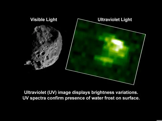
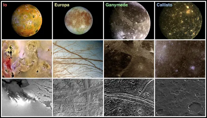
My Boards
View Pictures
  • My Boards

Mars Craters and Geological Features

Images of Mars highlighting craters and terrain features, showcasing a mix of color variations and geological structures.

Seasonal Frost in Terra Sirenum
277 assets in this story
6145-44688570
Spectrometer Images of Candidate Landing Sites for Next Mars Rover
6145-45103693
Different visualizations of an area with geometric geoglyphs at the Nasca World Heritage Site in Peru as seen by NASA's Uninhabited Aerial Vehicle Synthetic Aperture Radar (UAVSAR).
6145-45101301
This illustration shows some of the final images used to determine that the coast was clear for NASA's New Horizons' flight through the Pluto system.
6145-44749407
Changes in Titan's Lakes
6145-44572545
This is a vegetation map of the Raco, Michigan area produced from data acquired by NASA's Spaceborne Imaging Radar C/X-Band Synthetic Aperture Radar (SIR-C/X-SAR) onboard space shuttle Endeavour.
6145-44646367
Seen here are areas mapped on Saturn's moon Titan by the Cassini radar mapper using its synthetic aperture radar imaging mode. Shown are a variety of geologic features, including impact craters, wind-blown deposits, channels and cryovolcanic features
6145-52930293
Juno Zooms in on Jupiter's Moon Ganymede. JunoCam, the public engagement camera aboard NASA's Juno spacecraft, captured these views of Jupiter's moon Ganymede during a close pass on June 7, 2021. JunoCam was able to obtain significantly higher quality images compared to those taken by NASA's Voyager spacecraft in 1979 (upper left). In these images, JunoCam revealed 12 paterae - broad, shallow bowl-shaped features on a planetary body's surface - only two of which are evident in the Voyager data. These features were likely formed by late-stage volcanic processes. https //photojournal.jpl.nasa.gov/catalog/PIA25721
6145-44660985
This artist concept shows that NASA's Spitzer Space Telescope found evidence that this star, the remains of which are named Cassiopeia A, exploded with some degree of order, preserving chunks of its onion-like layers as it blasted apart.
4384-228
Neisseria gonorrhoeae Bacterium
6145-44605655
North Polar Water Ice by Weight
6145-44562249
NASA's Galileo spacecraft imaged Io at high spectral resolution during the G2 encounter on Sept. 6, 1996.
6145-44731153
Comparing Mercury's Exosphere between Two Flybys
6145-44562304
This image was acquired on May 6, 1997 while Io was in eclipse (in Jupiter's shadow) during NASA's Galileo spacecraft's eighth orbit, and reveals several dynamic processes.
6145-45245878
DUCT LAB SUPERSONIC WIND TUNNEL MACH 4.3 - 4.4 FLOW SHADOWGRAPH IMAGES TAKEN IN SEPTEMBER 1998
6145-45092830
In this perspective view, NASA's MESSENGER spacecraft looked northwest over the Caloris Basin, a depression about 1500 km in diameter formed several billion years ago by the impact of a large projectile into the surface of Mercury.
6145-44638824
Radargrams of Buried Basin from Two Adjacent Orbits
6145-44716024
A Closer Look at Albedo and Color Variations on Mercury
6145-44857747
These postage-stamp images taken by NASA's Galaxy Evolution Explorer are helping to solve a mystery -- why do the littlest of galaxies produce the biggest of star explosions, or supernovae
6145-44846853
This pair of images shows the area affected by the impactor released by NASA's Deep Impact spacecraft in July 2005.
6145-44653272
Viking 1's 30th!
6145-45105996
Each of these two montages shows four synthetic views of Titan created using data acquired by NASA's Cassini spacecraft between 2004 and 2015. With each flyby, a brief opportunity to add small pieces to the overall mapping coverage of Titan.
6145-44972583
This topographic map shows four semifinalist sites located close together in the Elysium Planitia region of Mars; the mission InSight will study the Red Planet's interior to advance understanding of the processes that formed and shaped the rocky planets.
6145-45085126
2014 in MESSENGER Images
6145-44729830
The Mimas Atlas
6145-51864929
Velocity measurements in meters per second at a 0° wind angle, with the stadium width perpendicular to the flow, and with the stadium rotated to a 45° wind angle. The blue color indicating a negative velocity shows the flow in the opposite of the wind direction. (DTRA image)
6145-45264624
This compilation of images from nine Cassini flybys of Titan in 2009 and 2010 captures three instances when clear bright spots suddenly appeared in images taken by the spacecraft's Visual and Infrared Mapping Spectrometer. The brightenings were visible only for a short period of time -- between 11 hours to five Earth weeks -- and cannot be seen in previous or subsequent images. The Cassini spacecraft ended its mission on Sept. 15, 2017.
6145-44909970
This map from NASA's Dawn mission indicates the presence of hydrated minerals on the giant asteroid Vesta about 30 degrees north latitude, in August 2011. At the time, it was winter in Vesta's northern hemisphere.
6145-44609364
Getting Closer
6145-45122038
These two images show Shallow Radar instrument data from two tracks in a part of Mars' Utopia Planitia region where the orbiting, ground-penetrating radar on NASA's Mars Reconnaissance Orbiter detected subsurface deposits rich in water ice.
6145-44710255
Olivine, Phyllosilicates, and Ancient Crater Rims
6145-52961083
. Hot Spots of Subsidence, Uplift in New York City. Using radars on the ESA (European Space Agency) Sentinel-1 satellites, along with advanced data processing techniques, a team of researchers measured upward and downward vertical land motion - also known as uplift and subsidence - across the New York City metropolitan area from 2016 to 2023. They mapped the motion in detail and pinpointed specific locations seen here - an airport runway and part of a Superfund site - that were notably sinking or rising. Runway 13/31 at LaGuardia Airport in Queens, left, is co-located with a former landfill and subsiding at a rate of about 0.15 inches (3.7 millimeters) per year. Part of the Newtown Creek Superfund site in East Williamsburg, Brooklyn, right, is rising unevenly by about 0.06 inches (1.6 millimeters) per year, possibly due to groundwater pumping and treatment activities. The site is undergoing extensive environmental remediation to address decades of pollution, including the Greenpoint oi
6145-45299527
This map of Mars shows the landing site for NASA's Perseverance rover in relation to those of previous successful Mars missions. The newest addition to the group, Perseverance is set to land in Jezero Crater on Feb. 18, 2021.
6145-44664421
Gypsum at Olympia Undae
6145-45079056
Five images of comet Siding Spring taken within a 35-minute period as it passed near Mars on Oct. 19, 2014, provide information about the size of the comet's nucleus. The images were acquired by the HiRISE camera on NASA's Mars Reconnaissance Orbiter.
6145-44945972
This graphic illustrates the evolution of satellites designed to measure ancient light leftover from the big bang that created our universe 13.8 billion years ago; NASA's COBE Explorer (left) and WMAP (middle), and ESA's Planck (right).
6145-44669361
A Cold Day in Richardson Crater
6145-44731116
MESSENGER's Enhanced Coverage of Mercury's Surface
6145-44505328
Mars Polar Lander Landing Zone Compared With JPL
6145-44702016
Mercury Laser Altimeter (MLA) Images Mercury from 4 Million Kilometers
6145-44784709
Craters and the Tell-Tale Signatures
5514-53894985
HIV vaccine experiment conducted by Swedish professor Eric Sanstram, in Dar es Salaam, Tanzania.
6145-45266917
This graphic maps locations of the sites where NASA's Curiosity Mars rover collected its rock and soil samples for analysis by laboratory instruments inside the vehicle. It also presents images of the drilled holes where 21 rock-powder samples were acquired. The diameter of each drill hole is about 0.6 inch (1.6 centimeters), slightly smaller than a U.S. dime. The images used here are raw color, as recorded by the rover's Mars Hand Lens Imager (MAHLI) camera. Notice the differences in color of the material at different drilling sites. For the map, north is toward upper left corner. The scale bar represents 2 kilometers (1.2 miles). The base map is from the High Resolution Imaging Science Experiment (HiRISE) camera on NASA's Mars Reconnaissance Orbiter.
6145-44784491
Using observations from NASA's Mars Reconnaissance Orbiter, this map shows five locations where fresh impact cratering has excavated water ice from just beneath the surface of Mars.
6145-44562419
NIMS Observes the Structure and Composition of Jupiter's Clouds
1746-19661388
Supernova remnants resolved at GeV gamma rays from of different ages and in different environments. W51C, W44 and IC 443 are middle-aged remnants between 4,000 and 30,000 years old. Credit NASA. Science Astronomy
6145-44608324
Comparison of a Computer Graphic Model of the Opportunity Lander and Rover with MOC Orbital Image
6145-44522397
On January 26, 2001, the city of Bhuj suffered the most deadly earthquake in India's history. This stereoscopic image was generated from NASA's Landsat satellite and data from Shuttle Radar Topography Mission (SRTM).
6145-44980323
The new AllWISE catalog will bring distant galaxies that were once invisible out of hiding, as illustrated in this image. At right, a portion of the sky available before the AllWISE project; at left, the same part of the sky in a new AllWISE image.
6145-44915109
New results from the Sample Analysis at Mars, or SAM, instrument on NASA's Curiosity rover detected about 2,000 times as much argon-40 as argon-36, which weighs less, confirming the connection between Mars and Martian meteorites found on Earth.
6145-44630056
Cassini's April 16 Flyby of Titan
6145-45257862
This graphic maps the first 16 sites where NASA's Curiosity Mars rover collected rock or soil samples for analysis by laboratory instruments inside the vehicle. It also presents images of the drilled holes where 14 rock-powder samples were acquired.
6145-44841787
On this map of Mars, spectrometers on spacecraft orbiting Mars have detected clay minerals (green) and hydrated minerals-- clays, sulfates and others (blue).
6145-44665768
NASA's Dawn asteroid lithograph of Eros and other asteroids.
6145-44529672
Northern Plume and Plume Deposits on Io
6145-45096657
This image contains the initial, informal names being used by NASA's New Horizons team for the features and regions on the surface of Pluto. These names have not yet been approved by the International Astronomical Union (IAU).
6145-44617606
Phoebe's Mineral Distribution
6145-44784222
One Week to Mercury Flyby 3 - A Look at the Planned Imaging Coverage
824-63203296
Optical Coherence Topography (OCT) image, showing a macular map. On this image, the left eye to prevent glaucoma.
6145-44617624
Phoebe in Ultraviolet
6145-44636103
Cassini's Close Look at Tethys
6145-44719855
Mapping a Volcano
6145-52930291
Radar Observations of Elongated Near-Earth Asteroid 2011 AG5. This collage represents NASA radar observations of near-Earth asteroid 2011 AG5 on Feb. 4, 2023, one day after its close approach to Earth brought it about 1.1 million miles (1.8 million kilometers, or a little under five times the distance between the Moon and Earth) from our planet. While there was no risk of 2011 AG5 impacting Earth, scientists at NASA's Jet Propulsion Laboratory in Southern California closely tracked the asteroid, making invaluable observations to help determine its size, rotation, surface details, and shape. More than three times as long as it is wide, 2011 AG5 is one of the most elongated asteroids to be observed by planetary radar to date. This close approach provided the first opportunity to take a detailed look at the asteroid since it was discovered in 2011, showing an object about 1,600 feet (500 meters) long and about 500 feet (150 meters) wide - dimensions comparable to the Empire State Building
6145-44702054
Complex Sulfate Deposits in Coprates Chasma
6145-45094661
This image captured by a prototype NASA satellite instrument at NASA's California Laboratory for Atmospheric Remote Sensing (CLARS) shows a persistent methane hotspot (central red area) over Los Angeles basin.
6145-44581476
An 8-kilometer (5-mile) wide crater of possible impact origin is shown in this stereoscopic view of an isolated part of the Bolivian Amazon.
6145-44784710
Nearside of the Moon
6145-44560459
Landscape Comparisons - Galilean Satellites
4128-V58577045
6145-45110883
This graphic maps locations of the first 14 sites where NASA's Curiosity Mars rover collected rock or soil samples for analysis by laboratory instruments inside the vehicle.
6145-44952043
This pair of images taken a few minutes apart show how laser firing by NASA's Mars rover Curiosity removes dust from the surface of a rock. The images were taken by the remote micro-imager camera in the laser-firing Chemistry and Camera (ChemCam).
6145-58971852
Atmospheric methane is a potent greenhouse gas and an important contributor to air quality. Future instruments on orbiting satellites can help improve our understanding of important methane emission sources. NASA conducts periodic methane studies using the next-generation Airborne Visible/Infrared Imaging Spectrometer (AVIRIS-NG) instrument. These studies are determining the locations and magnitudes of the largest methane emission sources across California, including those associated with landfills, refineries, dairies, wastewater treatment plants, oil and gas fields, power plants, and natural gas infrastructure. These three images show concentrations of methane in a natural gas plume relative to background air measured by AVIRIS-NG, overlaid on true-color land surface images (source Google Earth). The aircraft was flying at an altitude of about 10,000 feet (3,000 meters) above ground level and the AVIRIS-NG image pixels are each about 10 feet (3 meters) across. The plume shape varies
6145-58971723
Shown here is an annotated representation of the 13 sample tubes containing rock-core samples that are being carried aboard NASA's Perseverance rover as of Dec. 12, 2023, when the mission was marking its 1,000th Martian day, or sol, on the Red Planet. To the right of each sample is the associated abrasion patch that was created at the same location where the core was extracted. The images of the samples and patches are grouped into gray boxes labeled with the name of the four rover science campaigns during which they were collected, from initial campaign to current Crater Floor, Delta Front, Upper Fan, and Margin. The images of the cored samples were collected by the Sampling and Caching System Camera (known as CacheCam). Directly below each image of a cored sample is its name, as chosen by the Perseverance science team. The images of the abrasion patches were collected by the WATSON (Wide Angle Topographic Sensor for Operations and eNgineering) camera on the SHERLOC (Scanning Habitabl
6145-44557588
Sockets and Pebbles
6145-44612020
Keepers of the Hematite
6145-44628797
Cassini's Closest Enceladus Flyby
6145-44711631
This calibration image presents three-dimensional data from the atomic force microscope on NASA's Phoenix Mars Lander, showing surface details of a substrate on the microscope station's sample wheel.
6145-44506436
NEAR: From Planning to Data Analysis
PREVIOUS
of 3
NEXT
2401 S. Ervay, Suite 206
Dallas, Texas 75215
United States
Get Started
Free ResearchMy BoardsMy Cart
For Creators
How To License Your ContentContributor PortalFrame of Mind
Resources
API accessPricing
Contact
+1 866 236 0087help@viewpictures.co.uk Contact form
©2026 View Pictures. All Rights Reserved. -A
This site is protected by reCAPTCHA and Google Privacy Policy and Terms of Service apply.