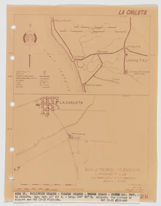
Survey and Land PlansHistorical maps and land plans detailing various locations in the U.S. during the 18th and 19th centuries, showing land use and structures. Landing Fields - Philippines - La Carlota, Aerial Photograph. 267 assets in this story6145-505118966145-551333836145-505234386145-487178856145-485808716145-505119726145-484476896145-489828556145-542685416145-485593256145-513861646145-438707576145-545240826145-426208176145-559570676145-559137756145-487326326145-484480646145-523592256145-484494726145-484472296145-486850786145-484464106145-484597486145-458481426145-592501376145-484908816145-595974386145-426031516145-484467536145-545264566145-529444506145-559288026145-486970656145-484876966145-504460236145-505304276145-545254836145-592501336145-559246136145-513907046145-303066646145-505612146145-505235476145-528307446145-504466256145-506460056145-546036926145-559283586145-595990146145-595638096145-505611046145-559288916145-484893544409-172746486145-542693154409-215203086145-505119856145-542689816145-545248056145-484476566145-438032266145-545245276145-528317156145-484485656145-426066546145-484471576145-504442456145-484483446145-529450276145-506615106145-545498486145-559561376145-523591956145-484471966145-529446206145-426120896145-545258526145-484447076145-559287326145-484751436145-484835226145-545256916145-484466096145-435062906145-487520916145-484593334443-732277216145-513864826145-513920496145-559130616145-595971876145-505611506145-513875986145-545254144409-186024876145-545258096145-542687006145-545260376145-48444783 PREVIOUS of 3 NEXT