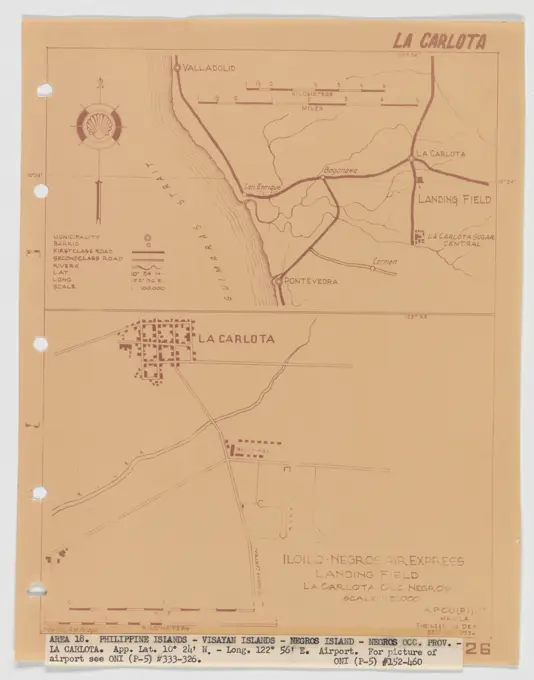
Survey and Land PlansHistorical maps and land plans detailing various locations in the U.S. during the 18th and 19th centuries, showing land use and structures. Landing Fields - Philippines - La Carlota, Aerial Photograph. 267 assets in this story6145-528345106145-484809776145-545246916145-513926736145-545256356145-542686466145-456231576145-504442956145-551753046145-505724186145-484768436145-519398496145-505612026145-505743896145-303065546145-505182186145-487326316145-545480926145-484419926145-486730626145-484368646145-595884596145-485006516145-299296736145-559152606145-505114886145-299240706145-484898976145-529442416145-529450546145-551671226145-559282806145-504455496145-505198246145-542693316145-484865124443-217736006145-484352356145-504442336145-484565296145-528290436145-545241136145-487178576145-528288496145-588932766145-484451446145-484485426145-545677016145-484807256145-484939026145-513979346145-299293566145-426207526145-504439016145-588408196145-484866236145-438095566145-484351516176-673044986145-484450916145-484381736145-505478336145-505660566145-484450286145-486729606145-440258356145-484785616145-545245686145-438032636145-426195216145-551676326145-438613174443-196073404128-482853256145-529447556145-484468136145-595852256145-551700596145-591016326145-456557586145-589434486145-426036476145-559564936145-462508596145-426121826145-484741926145-484879066145-592506876145-523597906145-542674816145-487178066145-484892551788-352676145-551333696145-303072106145-542677566145-484488336145-484560444443-754626306145-53168412 PREVIOUS of 3 NEXT