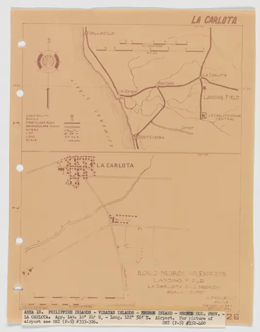
My Boards
View Pictures
  • My Boards

Survey and Land Plans

Historical maps and land plans detailing various locations in the U.S. during the 18th and 19th centuries, showing land use and structures.

Landing Fields - Philippines - La Carlota, Aerial Photograph.
267 assets in this story
6145-48483128
N.N., Westend station of the city and ring railway, Berlin. (From: Atlas to the magazine for Building, ed. V.F. Endell, Jg. 37, 1887) (1887-1887): site plan, cut. Lithograph on paper, 29.4 x 45.7 cm (including scan edges) Kayser & von Großheim : Bahnhof Westend der Stadt- und Ringbahn, Berlin. (Aus: Atlas zur Zeitschrift für Bauwesen, hrsg. v. F. Endell, Jg. 37, 1887)
6145-48469126
Jansen Hermann (1869-1945), development plan of the city expansion, Nörenberg/Pomerania (August 15, 1927): General development plan: basic plan and site plan 1: 1000, consisting of four leaves: Inv.No. 21404a, 21405b, 21406c, 21407d, here sheet 2. Print on cardboard, 74.3 x 103.1 cm (including scan edges)
6145-51397723
'Ocean View' at Pigeon Cove in Town of Rockport, Mass., street location plan , Streets
6145-50661845
Cadastral map (minute plan) of the municipality of Lauwerecht Section A, third page with the boundaries of the land ownership and the relevant plot numbers in the area roughly bordered by De Biltsche Grift, Stadsbuitengracht, Vecht and the InundaDade. To the right of the center the Kwakkeldijk and the oats with the black water.
6145-42624282
N.N., Haderslebener Förde, Hadersleben: site plan 1: 5000. Lithograph colored on paper, 62.7 x 123.4 cm (including scan edges) N.N. : Haderslebener Förde, Hadersleben
6145-52944256
Part Plan Development Norfolk Navy Yard. Glass Plate Negatives of the Construction and Repair of Buildings, Facilities, and Vessels at the New York Navy Yard.
6145-59241190
Map of the siege of Londonderry, 1689, 1689 print Map of the siege of Londonderry by the army of Jacobus II, April 18 to July 28, 1689. The map includes a separate text sheet with the legend. Northern Netherlands paper etching / engraving siege, position war. maps of cities Londonderry
6145-29095500
1869 Knapp Map of the Southeast Corner of Central Park (Grand Army Plaza) New York City
6145-50661849
Cadastral map (minute plan) of the municipality of Catharijne, Section B, second sheet with the borders of the land ownership and the relevant plot numbers in the southern area of the Polder Lage Weide between the Amsterdamsestraatweg, Vleutense Wetering and a line from the Oude Rijn extended to the north.
6145-48444636
Barth Erwin (1880-1933), Buniamshof sports field in Lübeck (01.1911): Floor plan of the facility with that of the house with the surrounding area, heights 1: 200, scale bar, legend with name of the parts. Ink on transparent, 44.8 x 53 cm (including scan edges) Barth Erwin  (1880-1933): Sportplatz Buniamshof, Lübeck
4443-73241715
Netherlands, Suite of ten maps and plates of the draining of the Haarlemmermeer 1843-1860, Map III. The steam engine De Leeghwater, near the Kaag. 1 October 1843, Map showing the location of the steam engine De Leeghwater near the Kaag, 1 October 1843. On the right three cross-sections and a view of the steam engine. Inscriptions in Dutch and French. Part of a suite of ten plates of the draining of the Haarlemmermeer, 1843-1860., print, prent, map, prints, etchings, Frederik Muller Historieplaten, height 560 mm, width 760 mm, print maker, printmaker, 1843 - 1861, paper, papier, lithografie (technique), handkleuring
6145-48444781
Barth Erwin (1880-1933), Garden Nasch in Berlin-Grunewald (06.1924): Floor plan of the planned garden with a changed property boundary and with floor plan of the residential building, altitude lines and legend 1: 200, scale bar. Pencil watercolor over a break on the box, 69.2 x 57.5 cm (including scan edges) Barth Erwin  (1880-1933): Garten Nasch, Berlin-Grunewald
6145-54368705
Volcanoes - After Mount St. Helens Eruption - Washington. Photographs Relating to National Forests, Resource Management Practices, Personnel, and Cultural and Economic History
6145-59597057
Map of Dam Square with the positions of the militia companies, 28 June 1748, Anonymous, in or after c. 1748 print Map of Dam Dam in Amsterdam and the surrounding area with the positions of the Compagnies Schutters who had to maintain order during the executions of two participants in the tenant riot on 28 June 1748. Under the legend A-L.  paper engraving maps of cities Dam. Waag on Dam Square
6145-54523808
Cartographic, Maps. 1884 - 1936. Lionel Pincus and Princess Firyal Map Division. Fire insurance , New York (State), Real property , New York (State), Cities & towns , New York (State) Brooklyn V. 11, Plate No. 14 Map bounded by New York Bay, Narrows Ave., Latting Pl.
6145-48504240
Thür Georg (1846-1924), Pathological Institute of the Christian Albrechts University Kiel (January 31, 1908): Department 1: 250. Lithograph, 50.4 x 73.3 cm (including scan edges)
6145-52830532
Situation plan of the Krieau trotting system in Vienna in 1899, showing layout and spatial organization, drawn on medium-strong paper.
6145-59568670
Map of the city and the castle of Bredevoort with the reinforcements, 1597, 1647 - 1649 print Map of the city city and the castle of Bredevoort with the reinforcements, at the time of the conquest by the State Army under Prince Maurits, 12 October 1597. Double folded leaves printed on the back with text in Latin.  paper etching maps of cities. capture of city (after the siege) Bredevoort
6145-48448815
Jansen Hermann (1869-1945), total development plan Tarsus (25.08.1937): New train station and station forecourt: site plan and upright 1: 500. Pencil, coal, ink on transparent, 48 x 52.4 cm (including scan edges) Jansen Hermann  (1869-1945): Gesamtbebauungsplan Tarsus
6145-45830065
Map of Londonderry, 1689. Map of the Londonderry Siege by the Army of Jacobus II, April 18 to July 28, 1689. A separate text sheet with the legend is part of the map.
6145-45675486
Card III. The steam tool the empty water, at the Kaag. 1 October 1843; Suite of ten cards and plates of the Drying of the Haarlemmermeer 1843-1860. Card with the location of the steam pumping station De Leeghwater at De Kaag, October 1, 1843. Right three intersections and a view of the steam pumping station. Inscriptions in Dutch and French. Part of a suite of ten plates of the Drying of the Haarlemmermeer, 1843-1860.
4220-21922802
Bird's-eye view of London at  the end of the 19th century : Fleet Street and Ludgate Hill  to St Paul's and Cheapside       Date: 1899
6145-50572412
Plan of the Norwood Headland in Rockport, Mass. ,
6145-43771999
Map of Malden, 1795 ,. Lucius Beebe Memorial Library Historic Maps
6145-48444978
Barth Erwin (1880-1933), Volkspark Rehberge in Berlin-Wedding (05.1928): Overall system in the floor plan with information from numbered perspectives for perspective drawings 1: 2000, scale bar, stamp. Ink, pencil over a break on paper, 69.3 x 72.6 cm (including scan edges) Barth Erwin  (1880-1933): Volkspark Rehberge, Berlin-Wedding
6145-54526429
Cartographic, Maps. 1898. Lionel Pincus and Princess Firyal Map Division. Fire insurance , New York (State), Real property , New York (State), Cities & towns , New York (State) Bronx, V. A, Plate No. 39 Map bounded by Elberon Ave., Bronx & Pelham Parkway, Pilgrim Ave., Liberty Alice St.
6176-67050083
'Plan of the Battle of Kirbekian, (February 10, 1885)', c1885. Artist: Unknown.
6145-55957639
Plate IV. Sketches of villages of the Croton watershed: Putnam County showing sketches of: Patterson, Carmel, and Brewster Cartographic. Maps. 1888. Lionel Pincus and Princess Firyal Map Division. Croton River Watershed (N.Y.), Watersheds , New York (State) , Putnam County, Aqueducts , New York (State) , Putnam County, Cities and towns , New York (State) , Putnam County, Putnam County (N.Y.), Water-supply , New York (State) , New York, Croton River (N.Y.), Croton Aqueduct (N.Y.)
6145-48444363
Lent Alfred (1836-1915), blast furnace system with a connecting railway. Schinkel competition 1863 (1863): site plan, off -road profile 1: 1250; Scale bar. Ink on cardboard, 64.8 x 101.9 cm (including scan edges) Lent Alfred  (1836-1915): Hochofenanlage mit Verbindungsbahn. Schinkelwettbewerb 1863
6145-52831720
A 1846 pencil presentation with black pen and multicolored details by Karl Hacker showing a garden plan for the Burggarten redesign project in Hofburg, Vienna I.
1746-111906489
Plan showing transportation of water across Mars by means of canals and pumping stations. Dated 20th century
6145-52828272
Mezzanine floor plan of Haus am Michaelerplatz (Looshaus) in Vienna, designed by Adolf Loos, shown in blueprint dated 1909-1911.
6145-59576985
Matching map for the rebuilding of the disaster area, 1807, Daniël Vulawaard (I), 1807 print Competition map for submitting proposals for the rebuilding of the site on either side of the Steenchuur, released after the gunpowder disaster in Leiden on January 12, 1807. The map includes a memorandum stating that a university building should rise on the site.  paper etching maps of cities Leiden
6145-55957641
Plate II. Sketches of villages of the Croton watershed: Westchester County, pt. A showing sketches of: Bedford Station, Cross River, Katonah, and Mt. Kisco Cartographic. Maps. 1888. Lionel Pincus and Princess Firyal Map Division. Croton River Watershed (N.Y.), Watersheds , New York (State) , Westchester County, Aqueducts , New York (State) , Westchester County, Cities and towns , New York (State) , Westchester County, Westchester County (N.Y.), Water-supply , New York (State) , New York, Croton River (N.Y.), Croton Aqueduct (N.Y.)
6145-59307706
Vesting map of Harderwijk, Anonymous, c. 1650 - c. 1799 drawing On the left a bowl: range of 50 rods. On the right a legend.  parchment (animal material). watercolor (paint). ink brush / pen maps of cities. fortress Harderwijk
6145-59334621
View of Thames Ditton, Henry W. Taunt, 1871 photograph  Hemes ditton photographic support albumen print river Thames Ditton. Theems
6145-48718409
Plan and section, Salmon River gold district, Halifax Co., N.S , Geology, Nova Scotia, Halifax County, Maps, Mines and mineral resources, Nova Scotia, Halifax County, Maps, Geology, Nova Scotia, Port Dufferin, Maps, Mines and mineral resources, Nova Scotia, Port Dufferin, Maps, Gold mines and mining, Nova Scotia, Maps, Port Dufferin N.S., Maps, Halifax N.S. : County, Maps Norman B. Leventhal Map Center Collection
6145-29095502
1868 Vaux Olmstead Map of Central Park, New York City
6145-48456280
Guth Hermann (1851-1924), Gymnasium Lichterfelde (without date): Not yet recorded. Material/technology N.N. recorded, 46.4 x 46.1 cm (including scan edges) Guth Hermann  (1851-1924): Kreishaus Recklinghausen
4220-21917311
The town and harbour of  Cowlang in southern India,  where the Portuguese maintain  a trading post or settlement.        Date: 1671
6145-44031505
Plan from Friedrichsholm otherwise Genandt
6145-54269667
Drawing.Rigggritter to the archipelago cruiser Wilder sand made by Albert Anderson for landlord M. Wilson 1910.
6145-59252465
De Nieuwe Maas, from the Oude Haven in Rotterdam to the Voorhaven in Schiedam on the occasion of the competition of the Royal Dutch Yachtclub on June 10, 1846, 1846 print Ticket of the Nieuwe Maas between Schiedam and Rotterdam, the location of the first rowing competition of the Royal Dutch Yachtclub, held on 10 June 1846. See also the program on the other side of the magazine. Netherlandsprinter: The Hague paper  maps of separate countries or regions Mesh. Rotterdam
6145-48446745
Jansen Hermann (1869-1945), construction of a settlement for the non-profit small house construction company in Berlin-Heiligensee (10.1920): basic plan with altitude lines and forest stock 1: 2500. Ink, pencil, colored pencil on transparent, 35.5 x 64 cm (including scan edges) Jansen Hermann  (1869-1945): Bau einer Siedlung für die gemeinnützige Kleinhausbaugesellschaft, Berlin-Heiligensee
6176-61905118
Image  from page 182 of 'Jacques Cartier and his four Voyages to Canada an essay with historical, explanatory and philological notes. With a preface by George Murray.' .
6145-29657091
Collection of the Dutch Heidematschappij. Maps, Haagsche Beemden. undated. Princenhage
6145-42603312
Cramer Friedrich, main station in Hanover. Schinkel competition 1869 (1869): site plan 1: 2500; Scale bar. Tusche watercolor on the box, 62.9 x 142.8 cm (including scan edges) Cramer Friedrich : Hauptbahnhof Hannover. Schinkelwettbewerb 1869
6145-42625573
N.N., Luminous Fire, Ranzow, Collicker location: Location plans 1: 150000, 1: 500. Lithograph on paper, 35.2 x 88.8 cm (including scan edges)
6145-48473728
Böhmer Franz (1907-1943), vineyard guard (December 14, 1926): Department 1: 500. Tusche watercolor on transparent, 22.5 x 28.7 cm (including scan edges)
6145-48445180
Barth Erwin (1880-1933), green area at the Buschkrug in Berlin-Britz (02.1928): Case in the floor plan with heights 1: 500, stamp. Colored pencil, ink, ink colored over a break on the box, 34.5 x 56.6 cm (including scan edges) Barth Erwin  (1880-1933): Grünanlage am Buschkrug, Berlin-Britz
6145-42640500
Polack, garrison cadet facility in Naumburg/Saale (1900): River Bathing establishment: site plan 1: 2500. Lithograph, 53.1 x 74.6 cm (including scan edges)
6145-55167334
Nuova pianta degli scavi di Pompei. Includes index to points of interest. Inset: Neapolis and environs.. Located at the southeastern base of Mount Vesuvius, the ruins of the ancient city of Pompeii were discovered in the late 16th century; however, serious archaeological excavations did not begin at the site until the mid-18th century. The city had been "preserved in time" for nearly 1,700 years after Vesuvius exploded in 79 CE and buried the site in nearly 23 feet of volcanic debris. The 1862 map displayed here illustrates the excavations of Pompeii as they existed at that time, and lists 95 points of interest, including the Forum (65), the Triangular Forum (84) and the Amphitheatre (89)... , Italy  , Koni  ,region   , Napoli  ,province   , Pompeii  ,area
6145-48444667
Barth Erwin (1880-1933), systems of the Lauenburg Jäger-Battalion No. 9 in Ratzeburg (05.1904): Floor plan of the casino type 1: 250. Tusche watercolor on the box, 68.1 x 42.7 cm (including scan edges) Barth Erwin  (1880-1933): Anlagen des Lauenburger Jäger-Bataillons Nr.9, Ratzeburg
6145-29574155
Anefo photo collection. Pictures prints writings. Prints, writings. July 20, 1989
6145-29671051
Photo collection Government information service. Exhibition European urban design. undated
6145-48486624
N.N., Oder-Spree Canal. Route extension and deepening of the Friedrich Wilhelm Canal (05.1890): Stat. 51.4 - 54.5: site plan 1: 2500. Lithograph on paper, 47.3 x 65.1 cm (including scan edges) N.N. : Oder-Spree-Kanal. Strecke Erweiterung und Vertiefung des Friedrich-Wilhelm-Kanals
6145-50646575
City of Utrecht. / Project Spoorweg from Utrecht on Hilversum to Amsterdam.
6145-50444301
Jansen Hermann (1869-1945), total development plan Ankara. Partial development plan exterior (July 8th, 1935): Grund- und Zeitplan 1: 2000, prison and the surrounding area, development proposal. Ink on transparent, 37.1 x 37.3 cm (including scan edges) Jansen Hermann  (1869-1945): Gesamtbebauungsplan Ankara. Teilbebauungsplan äußere Stadt
6145-58980460
Plan of Marsland Hill (Pukaka), New Plymouth, shewing sic old barracks and military occupation 1856 - 1870 black-and-white negatives, gelatin dry plate negatives
6145-51835702
Winter Scene in Brooklyn Francis Guy (American, 1760-1820). Winter Scene in Brooklyn, ca. 1819-1820. Oil on canvas, 58 3/8 x 74 9/16 in. (148.2 x 189.4 cm).  From his studio on Front Street, now the Brooklyn neighborhood known as Dumbo, the painter Francis Guy observed his neighbors on a snowy day two centuries ago. They can be seen here engaged in such activities as getting a drink from a hand pump well, feeding chickens, and socializing. Guy represented the diversity of his Brooklyn neighborhood, portraying a range of classes (from manual laborers to merchants) and including a large concentration of Brooklyns free African American population. American Art ca. 1819-1820
6145-55958061
Cayuga County, Right Page Map of Genoa, King Ferry Cartographic. Atlases, Maps. 1904. Lionel Pincus and Princess Firyal Map Division. Real property , New York (State) , Herkimer County, Herkimer County (N.Y.) , Description and travel
6145-48448794
Jansen Hermann (1869-1945), total development plan in Gaziantep. Mal and Volkshaus-Park (29.08.1936): site plan 1: 500 and view from the river. Coal and ink on transparent, 58.4 x 66.9 cm (including scan edges) Jansen Hermann  (1869-1945): Gesamtbebauungsplan, Gaziantep. Gefallenenmal und Volkshaus-Park
6145-48447198
Jansen Hermann (1869-1945), settlement for war-damaged people in Potsdam (1933-1933): Department 1: 500. Colored pencils over a break on paper, 52.8 x 69.2 cm (including scan edges) Jansen Hermann  (1869-1945): Siedlung für Kriegsbeschädigte, Potsdam
6145-50513557
Proposed park system from the Common to the West Roxbury Park including the Back Bay and Muddy river improvements, Jamaica Pond and the Arnold Arboretum , Arnold Arboretum, Maps, Jamaica Pond, Boston Mass., Maps, Parks, Massachusetts, Boston, Maps, Boston Common Boston, Mass., Maps, Franklin Park Boston, Mass., Maps, Boston Mass., Maps Norman B. Leventhal Map Center Collection
6145-46750817
Big Kopparberg's mountain team. From Carl Sahlin's mountain historical collection.
6145-48447645
Jansen Hermann (1869-1945), total development plan Ankara. Partial development plan inner city (10.03.1935): site plan and profile 1: 500, Kizil Bey C., block west of the large market hall, Tahta Kale Mektebi, shop line. Light break on transparent, 32.2 x 35.3 cm (including scan edges) Jansen Hermann  (1869-1945): Gesamtbebauungsplan Ankara. Teilbebauungsplan innere Stadt
6145-50446032
Böhmer Franz (1907-1943), Thingplatz in Insterburg (05.1934): site plan. Light break on paper, 35.6 x 36.7 cm (including scan edges) Böhmer & Petrich : Thingplatz, Insterburg
PREVIOUS
of 3
NEXT
2401 S. Ervay, Suite 206
Dallas, Texas 75215
United States
Get Started
Free ResearchMy BoardsMy Cart
For Creators
How To License Your ContentContributor PortalFrame of Mind
Resources
API accessPricing
Contact
+1 866 236 0087help@viewpictures.co.uk Contact form
©2026 View Pictures. All Rights Reserved. -A
This site is protected by reCAPTCHA and Google Privacy Policy and Terms of Service apply.